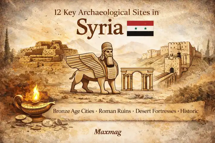
Syria sits at one of the great crossroads of human history, where trade routes, river valleys, desert corridors, and imperial frontiers overlapped for thousands of years. Archaeological Sites in Syria offer one of the clearest ways to see how urban life, kingship, religion, and long-distance exchange developed across the ancient Near East and eastern Mediterranean. From early Bronze Age courts to Roman colonnaded cities and late antique settlements, the country preserves a layered record of civilizations that rose, adapted, and disappeared, often on the same ground. To read Syria archaeologically is to read a landscape in which each era reused, challenged, or honored what came before it.
That density of evidence is what makes Syria so compelling for historians and general readers alike. The Archaeological Sites in Syria are not only monumental remains; they are archives of clay tablets, defensive walls, carved reliefs, temples, tombs, workshops, roads, and agricultural systems that document real communities making decisions about power, belief, labor, and survival. In a region often discussed only through modern crisis, archaeology restores a much longer timescale and a more humane one, reminding us that Syria has been central to global history for millennia.
The country’s material record stretches from early sedentary villages to sophisticated urban centers that helped shape diplomacy, writing, religion, and trade. Its deserts and river basins, coastal ports and inland plains, together preserve some of the most remarkable ancient ruins in Syria, each offering a different window into how societies organized themselves and how cultural contact repeatedly transformed the region.
Why Syria Matters Archaeologically
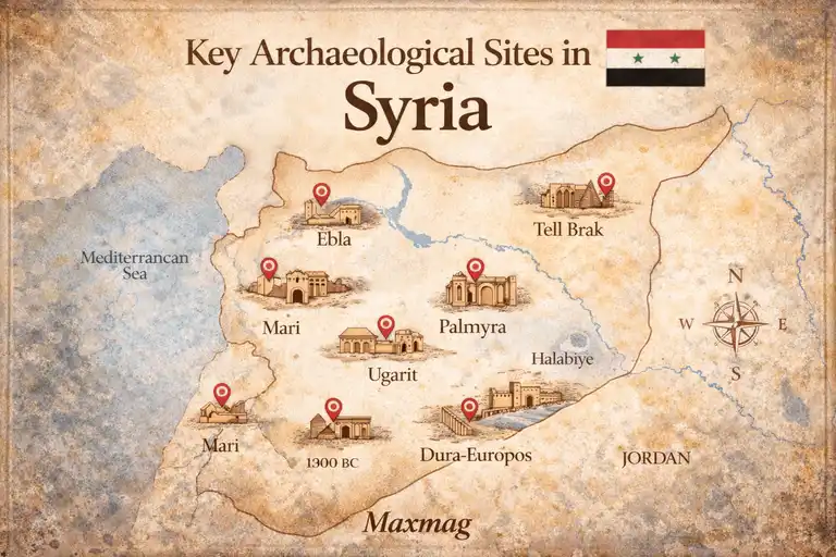
Syria matters archaeologically because it links multiple worlds at once. To the east lay Mesopotamia, to the south the Levant and Egypt, to the north Anatolia, and to the west the Mediterranean. That position meant that ideas, raw materials, military pressures, artistic styles, and religious traditions moved through Syrian landscapes constantly. Archaeology here does not reveal a single isolated tradition; it reveals a sequence of connected societies shaped by contact and adaptation. Ebla, Mari, Ugarit, Palmyra, and Bosra each belong to different historical settings, but together they show how Syrian communities turned geography into political advantage.
The country’s record is also unusually diverse in type. Syria preserves palace cities, temple complexes, caravan hubs, military frontiers, Byzantine villages, and Iron Age sanctuaries. Some sites are famous because they transformed scholarship, such as Ebla through its cuneiform archives, while others matter because they preserve daily life with unusual clarity, as at Dura-Europos or the Dead Cities. The cumulative effect is a deep, comparative record that helps scholars track changes in urban planning, ritual, trade, administration, literacy, and frontier life across several millennia.
Just as importantly, Syrian archaeology helps explain continuity as well as rupture. Kingdoms fell, empires changed hands, and faiths shifted, yet settlement often persisted because the same springs, river routes, uplands, and strategic corridors remained useful. Archaeology therefore reveals not only spectacular destruction or imperial replacement, but also long habits of habitation, reuse, and resilience that give Syria a uniquely rich historical texture.
Archaeological Sites in Syria and the Deep Historical Record
The density of surviving sites in Syria is meaningful because it reflects long-term human investment in a landscape that rewarded mobility as much as settlement. The Euphrates valley supported agriculture, transport, and royal administration; the inland plains fostered early cities and regional states; the coast opened onto maritime trade; and the steppe enabled caravan movement between settled zones. Rather than representing disconnected ruins, the major sites form a map of how people linked river systems, pasture, commerce, and sacred space over time.
Seen together, these places show historical continuity on a civilizational scale. Bronze Age capitals reveal some of the earliest experiments in centralized bureaucracy. Iron Age sanctuaries preserve local religious forms and regional artistic vocabularies. Hellenistic, Roman, and Byzantine cities show how older landscapes were absorbed into imperial systems without entirely losing their local identities. The site list below is therefore not just a catalog of monuments, but a guide to how Syria became one of the most important repositories of human historical memory.
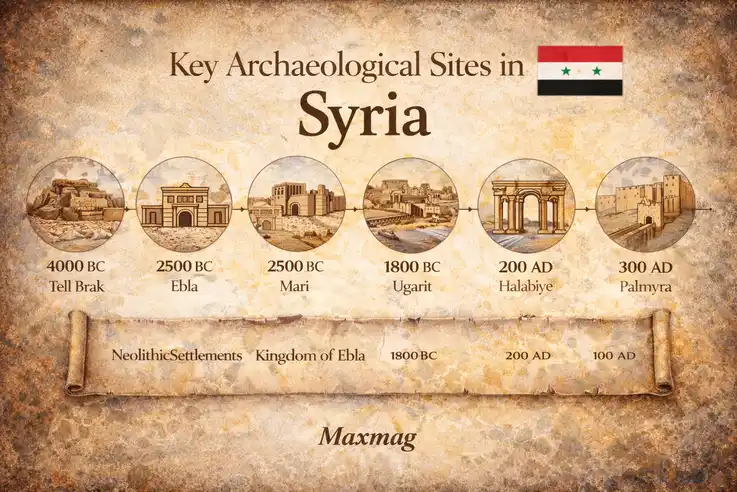
A Brief Historical Timeline of Syria
Human occupation in Syria reaches back to prehistory, with early sedentary communities and later Neolithic farming societies appearing in different ecological zones. By the third millennium BCE, urban centers such as Ebla and Mari had emerged as major powers, connected to wider networks of diplomacy, trade, and scribal culture. In the second millennium BCE, coastal Ugarit flourished as a maritime and commercial hub, while inland states navigated the pressure of larger regional empires.
During the first millennium BCE, the region saw Aramaean, Neo-Hittite, Assyrian, Babylonian, and Persian influence, leaving behind a highly stratified archaeological record of adaptation and political change. Hellenistic and then Roman rule reshaped urban landscapes through theaters, baths, temples, roads, and colonnaded avenues, while late antiquity and the Byzantine period produced churches, villages, and fortified lines across the countryside. For readers trying to situate the historic sites in Syria within a broader narrative, even a concise chronology makes clear that the country’s past was never static; it was repeatedly remade by conquest, exchange, and local persistence. Modern heritage debates also echo that depth, as PBS’s reporting on digital preservation in Syria shows when describing how scholars document threatened monuments for future recovery.
Medieval Islamic, Crusader, and later Ottoman periods added further layers, often reusing earlier foundations and urban fabrics rather than erasing them outright. That long sequence is why Syrian archaeology feels cumulative: every era left traces, and many of those traces remained physically entangled with what came before.
Ebla: A Landmark Among the Archaeological Sites in Syria
- Location: Tell Mardikh, Idlib Governorate
- Period / Civilization: Early and Middle Bronze Age; Eblaite kingdom
- Type of Site: Ancient city and palace center
- Why It Matters: Ebla transformed understanding of early state administration and diplomacy in the third millennium BCE.
Ebla was a major Bronze Age city-state whose power peaked in the third millennium BCE, when it controlled territory, trade, and diplomatic relations across a wide part of inland Syria. Excavated at Tell Mardikh, the site revealed a royal center with palatial structures, administrative quarters, and defenses that reflect the ambitions of a highly organized kingdom. Ebla was not a marginal settlement but a serious political actor, dealing with neighboring powers through tribute, alliance, and competition. Its rise matters in Syrian history because it demonstrates that early urban complexity in the region was not simply borrowed from Mesopotamia; it was also locally developed and adapted to western Syrian conditions.
The site’s most important discovery was the archive of thousands of cuneiform tablets found in the 1970s, which revolutionized scholarship on early Near Eastern administration, economy, and diplomacy. These tablets recorded deliveries, personnel, offerings, and political contacts, giving unusual precision to what might otherwise have remained a mute ruin. Monumental architecture, storerooms, and administrative spaces support the written evidence, showing how bureaucracy and royal display worked together. Few finds anywhere in the Near East have done more to illuminate the documentary side of early kingship.
Ebla reveals a society in which writing, taxation, redistribution, and ceremonial authority were already deeply intertwined. Workshops, agricultural accounting, and cultic references point to a world where palace power depended on managing food, labor, and belief at once. The site also anchors the broader archaeological heritage of Syria by proving how early and how sophisticated Syrian urban institutions could become. Even in damaged times, Ebla remains central to debates about state formation, literacy, and the human capacity to organize complexity. That is why its tablets still speak far beyond the mound where they were buried.
Mari
- Location: Tell Hariri, near the Euphrates
- Period / Civilization: Early and Middle Bronze Age; Mariote and Amorite rule
- Type of Site: Palace city and riverine political center
- Why It Matters: Mari preserves one of the ancient Near East’s richest palace complexes and textual archives.
Mari stood on the Euphrates as a strategic city linking Mesopotamia with western Syria and the Levant. Its position gave it political leverage, because whoever controlled Mari could monitor movement of goods, messengers, and armies along a vital corridor. The city flourished in multiple phases, but it is best known for the great palace associated with the early second millennium BCE. Mari’s historical role was both administrative and diplomatic: it was a court, a residence, a storage system, and a communications hub for a kingdom deeply tied to regional geopolitics.
Excavation brought to light an enormous palace with courtyards, reception rooms, temples, residential areas, and mural remains, all pointing to an advanced court culture. The archive of tablets from Mari is among the most informative bodies of written evidence for Near Eastern diplomacy, royal correspondence, and provincial management. Those letters make clear how information moved, how rulers assessed threats, and how fragile political alliances could be. The combination of architecture and text allows scholars to match administrative behavior to the spaces in which power was performed.
Mari offers a vivid insight into ancient life because it reveals a court that depended on logistics, ritual legitimacy, and constant communication. The site speaks to trade and governance, but also to human uncertainty: kings worried about supply, loyalty, omens, and rival states. For historians, Mari is indispensable because it turns royal politics from abstract chronology into lived administration. Its present-day relevance lies in how completely it documents the mechanics of early statecraft, reminding us that bureaucracy was already shaping ordinary lives four thousand years ago. In that sense, Mari is a city of documents as much as mudbrick.
Ugarit
- Location: Ras Shamra, near Latakia
- Period / Civilization: Late Bronze Age; Ugaritic kingdom
- Type of Site: Coastal city, palace, and port-connected urban center
- Why It Matters: Ugarit illuminates Bronze Age trade, religion, and alphabetic writing in the eastern Mediterranean.
Ugarit flourished on Syria’s Mediterranean coast in the Late Bronze Age, prospering from maritime links and from its ability to mediate between larger powers. The city belonged to a world of palaces, merchants, and diplomatic correspondence, where copper, timber, luxury goods, and prestige objects moved across the sea and inland routes. Its strategic role made it both wealthy and vulnerable, especially in an era when great kingdoms monitored coastal trade closely. In Syrian history, Ugarit represents the outward-looking, cosmopolitan dimension of the region’s past.
The site is famous for archives written in several languages and scripts, including the Ugaritic alphabetic cuneiform system that has made it crucial to the history of writing. Temples, palatial quarters, houses, storerooms, and imported goods all point to dense connections with Cyprus, Anatolia, Egypt, and the wider Levant. The textual discoveries are especially important because they preserve administrative records, diplomatic material, and mythological texts that illuminate religion as well as political life. Ugarit is one of those rare places where language, trade, and theology can all be studied through excavated evidence.
What Ugarit reveals most powerfully is the degree to which ancient Syrian society could be literate, international, and commercially agile at the same time. Households and institutions here participated in a world of exchange that crossed linguistic and cultural boundaries. Scholars still study the site not only for its famous texts, but for the way its urban fabric documents an economy built on mediation. Its wider significance lies in showing that Syria was never merely a borderland; it was often a connector. That is why Ugarit remains essential to any serious history of the Bronze Age Mediterranean.
Palmyra
- Location: Homs Governorate, Syrian desert oasis
- Period / Civilization: Hellenistic, Roman, and late antique Palmyrene culture
- Type of Site: Oasis caravan city
- Why It Matters: Palmyra shows how caravan wealth, local identity, and empire could intersect in dramatic urban form.
Palmyra rose in the desert because oasis geography made it an ideal intermediary between the Mediterranean world and the caravan routes reaching eastward. Though occupied earlier, the city is best known for its flourishing under Roman rule, when local elites translated trade wealth into monumental urbanism. Colonnaded streets, temples, tomb towers, and civic structures show a city that was simultaneously provincial and global. Palmyra’s historical role was not simply commercial; it was political, social, and symbolic, especially during the age of Zenobia, when the city briefly asserted imperial ambitions of its own.
Its most distinctive features include the monumental colonnade, funerary architecture, the Temple of Bel, and richly carved portrait sculpture that blends local and Greco-Roman visual traditions. Inscriptions in multiple languages reveal a multicultural society, while burial monuments preserve family identity and status in unusual detail. Archaeologists have long valued Palmyra because it documents how local aristocracies adapted imperial forms to their own traditions. The site’s architectural clarity also made it one of the best places to study urban planning in a caravan metropolis.
Palmyra reveals a society built on trade, social display, and religious plurality, where wealth from movement across harsh landscapes could be converted into monumental stone. One of the clearest lessons of Archaeological Sites in Syria is that desert spaces were not empty margins but active engines of connection, and Palmyra proves that magnificently. Its modern story, marked by deliberate destruction and global efforts at documentation, has also made it a symbol of heritage vulnerability. That painful history is precisely why Palmyra matters beyond tourism. It stands as a reminder that shared human memory can be both monumental and fragile.
Dura-Europos
- Location: Near Salhiyah on the Euphrates
- Period / Civilization: Hellenistic, Parthian, and Roman periods
- Type of Site: Frontier city and military settlement
- Why It Matters: Dura-Europos preserves one of the most informative snapshots of cultural coexistence on an imperial frontier.
Dura-Europos began as a Hellenistic foundation and later became a frontier city contested by larger imperial powers. Positioned above the Euphrates, it developed into a military and administrative outpost that also supported merchants, craftsmen, and families. Its value lies in the way it captures a lived borderland rather than a purely ceremonial center. This was a city shaped by garrison needs, taxation, movement, and vulnerability, where different traditions existed side by side under changing regimes.
Excavation uncovered houses, streets, a synagogue with famous wall paintings, Christian meeting spaces, temples, military installations, and siege remains associated with the Sasanian capture of the city in the third century CE. The variety of remains is extraordinary because it preserves religious, civic, and domestic life in a single urban setting. The evidence for siege warfare has also drawn scholarly attention, including discussions of tunnels, combat, and battlefield conditions. Dura-Europos is distinctive precisely because it is so complete in cross-section.
The site reveals how ordinary life on a frontier involved layered identities rather than neat cultural separation. Soldiers, traders, worshippers, and households occupied overlapping social worlds, adapting spaces for different needs as circumstances changed. Archaeological Sites in Syria are often discussed as monuments, but Dura-Europos shows how much can be learned from streets, rooms, and garrison infrastructure about coexistence and conflict. It remains crucial because it preserves the texture of borderland life with unusual immediacy. Here, empire is visible not as abstraction, but as architecture, labor, and risk.
Apamea
- Location: Hama Governorate, Orontes valley
- Period / Civilization: Hellenistic, Roman, and Byzantine periods
- Type of Site: Major city with colonnaded avenue
- Why It Matters: Apamea demonstrates the scale of imperial urbanism in inland Syria.
Apamea developed into one of the great cities of inland Syria, especially under Hellenistic and Roman rule, when it became a major administrative and commercial center in the Orontes valley. Its location connected fertile agricultural zones with broader regional routes, giving the city strategic and economic significance. Apamea’s role was urban rather than frontier-focused: it was a place of circulation, taxation, civic identity, and monumental display. In the broader Syrian story, it shows how imperial systems transformed already valuable landscapes into formalized cityscapes.
The site is best known for its immense colonnaded street, one of the grandest urban avenues in the Roman East, along with theater remains, public buildings, mosaics, and later Byzantine layers. These features reveal highly planned civic architecture designed to impress as well as to organize movement. Archaeologists have also used the site to study continuity between Hellenistic planning and later Roman urban embellishment. Even in damaged condition, the scale of Apamea still communicates the ambitions of cities integrated into imperial frameworks.
Apamea reveals the social choreography of an ancient city: processions, trade, administration, and public life all depended on carefully structured space. It also speaks to food supply and rural wealth, since cities of this size relied on productive hinterlands and stable transport. In recent years, widespread looting scars have made the site a stark example of how vulnerable major ruins can become when oversight collapses. That present-day relevance adds urgency to its study. Apamea matters because it shows both what a powerful city could build and how quickly unprotected heritage can be wounded.
Bosra
- Location: Daraa Governorate
- Period / Civilization: Nabataean, Roman, Byzantine, and early Islamic periods
- Type of Site: Urban center and provincial capital
- Why It Matters: Bosra preserves one of the Roman world’s best surviving theaters within a long-lived city.
Bosra occupies a key place in southern Syria, where caravan movement, imperial administration, and regional agriculture intersected. It became especially important under Roman rule as the capital of the province of Arabia, but its significance spans multiple eras, including Nabataean, Byzantine, and early Islamic phases. That longevity makes Bosra more than a single-period site; it is a city whose political and religious importance persisted because its location kept mattering. Few places in Syria illustrate urban continuity so clearly.
The city’s most celebrated feature is the monumental Roman theater, remarkably well preserved because later fortifications enclosed and protected it. Bosra also contains streets, baths, churches, mosques, and domestic remains that document changing urban priorities over centuries. Built largely in dark basalt, the city’s architecture has a distinctive visual character unlike many limestone sites in the region. The layering of structures makes Bosra especially valuable for understanding how cities adapted rather than simply vanished between antiquity and the medieval period.
Bosra reveals a community shaped by administration, pilgrimage, commerce, and regional connectivity. Public buildings point to imperial authority, while later religious monuments show how spiritual life and civic identity changed across time. Archaeological Sites in Syria often gain meaning through reuse, and Bosra is one of the clearest examples of that process in built form. Its preservation challenges today reflect the difficulty of protecting living urban environments that also contain irreplaceable antiquities. That tension makes Bosra historically rich and ethically important at the same time.
Ain Dara
- Location: Northwest Syria, near Afrin
- Period / Civilization: Iron Age; Neo-Hittite / Syro-Hittite context
- Type of Site: Temple sanctuary
- Why It Matters: Ain Dara is one of the most important Iron Age temple sites in the region.
Ain Dara was an Iron Age temple complex in northwest Syria, associated with the Syro-Hittite cultural world that emerged after the collapse of larger Late Bronze Age states. The sanctuary likely served ritual and political purposes, connecting local authority to divine presence through architecture and controlled access. Its importance lies in how clearly it represents regional religious traditions at a moment of political fragmentation and cultural reformation. Rather than a sprawling city, Ain Dara offers a focused view into sacred design and ideological power.
The temple became famous for its basalt reliefs, sculpted lions and sphinxes, and especially the giant carved footprints set into the floor sequence, among the most memorable symbolic features of any Levantine sanctuary. These details gave scholars rare material for thinking about movement, sacred performance, and visual theology. The building’s layout has also drawn comparison in wider debates about Iron Age temple traditions in the Near East. Even partial remains were enough to make Ain Dara indispensable for the study of early religious architecture.
Ain Dara reveals how ritual space could communicate hierarchy, awe, and controlled access long before worshippers reached an inner sanctuary. It shows that architecture itself was a language of authority. The severe damage the site suffered in modern conflict has made it one of the starkest examples of heritage loss in Syria, which in turn has sharpened attention to how quickly unique evidence can disappear. That present-day vulnerability is part of why it still matters. Ain Dara is a lesson in both ancient symbolism and modern responsibility.
Tell Brak
- Location: Northeastern Syria, Khabur region
- Period / Civilization: Late Chalcolithic through Bronze Age
- Type of Site: Early urban tell settlement
- Why It Matters: Tell Brak is vital to debates about the origins of cities in northern Mesopotamia and Syria.
Tell Brak is one of the most important prehistoric and early urban sites in northern Syria, with occupation spanning long periods before and after the emergence of city life. Its significance rests partly on its deep sequence and partly on its scale, which indicates that urbanization in the north followed its own trajectory rather than merely copying southern Mesopotamian models. The site served as a regional center in a landscape tied to agriculture, movement, and local political consolidation. For the history of urban origins, Tell Brak is a foundational case study.
Excavations have uncovered temples, administrative evidence, craft activity, mass deposits, and neighborhood remains that allow scholars to reconstruct the site’s growth over time. One of its most discussed features is the so-called Eye Temple and the associated figurines, which point to ritual practices and collective symbolism. The broad surface spread of remains has also informed discussions about low-density urbanism and early settlement expansion. Tell Brak is distinctive because it helps archaeologists think about how cities formed gradually and unevenly.
The site reveals that early urban life involved ritual, production, and social differentiation long before classical city forms emerged. It offers insight into how communities scaled up, how authority became visible, and how settlement patterns could change with new economic pressures. When Archaeological Sites in Syria are viewed across the very long term, Tell Brak becomes essential because it pushes the story back toward the beginnings of urban complexity. Its importance today lies in that deep-time perspective. It reminds us that cities were experiments before they were certainties.
Tell Halaf
- Location: Near Ras al-Ayn, northeastern Syria
- Period / Civilization: Neolithic Halaf culture and later Aramaean phases
- Type of Site: Multi-period tell settlement
- Why It Matters: Tell Halaf connects prehistoric cultural traditions with later Iron Age political development.
Tell Halaf is unusual because its name became attached both to a major Neolithic cultural horizon and to a later Iron Age center, making it a site of exceptional chronological reach. In prehistory, the broader Halaf culture is associated with finely painted pottery and village life across parts of northern Mesopotamia and Syria. Later, the mound was reoccupied in an Aramaean political context, demonstrating how strategic locations could be reused long after earlier communities had vanished. That layered occupation makes Tell Halaf especially instructive.
Excavations brought to light architecture, pottery, sculptural remains, and evidence of later elite display that gave the site importance in several fields at once. For prehistorians, the ceramics are central because they help define one of the region’s key cultural phases. For Iron Age scholars, later monumental elements reveal how emerging local rulers used visual culture to project authority. The site therefore bridges discussions that are often separated into distinct academic periods.
Tell Halaf reveals how the same landscape could support very different social worlds across time, from early village communities to later elite political centers. Its importance lies not in a single spectacular structure, but in the long conversation between periods preserved in its layers. Archaeological Sites in Syria often reward this kind of long reading, where deep stratigraphy matters as much as monumentality. That is why Tell Halaf continues to matter for both specialists and broader readers. It teaches continuity through change, which is one of archaeology’s most valuable lessons.
Halabiye
- Location: On the Euphrates, southeast of Raqqa
- Period / Civilization: Primarily Roman and Byzantine
- Type of Site: Fortified city and frontier stronghold
- Why It Matters: Halabiye demonstrates how river corridors were militarized and managed in late antiquity.
Halabiye occupies a commanding position on the Euphrates, where cliffs and river movement together created a naturally strategic setting. Strengthened in late antiquity, the site formed part of the defensive and administrative logic of the eastern frontier, where control of movement and communications mattered enormously. Its historical role was therefore military, but not only military: fortified settlements also supported supply, surveillance, and local civilian life tied to garrisons and transport. Halabiye belongs to the long story of Syria as a zone where empire had to be continuously negotiated.
The surviving walls, towers, and urban plan give the site a striking profile, allowing archaeologists to study fortification design adapted to local topography. Its placement along the Euphrates also helps scholars think about how defense, taxation, and movement intersected in border regions. While less famous than some Syrian sites, Halabiye offers unusually clear evidence for the practical architecture of late antique control. The site’s setting is part of what makes it distinctive: landscape and military logic are visibly fused.
Halabiye reveals that frontier life was built from routines of maintenance, provisioning, watchfulness, and constrained mobility. Fortified places like this shaped how merchants, officials, and local populations moved through the region. Archaeological Sites in Syria are especially revealing when they show not just ceremonial grandeur but the infrastructure of power, and Halabiye does exactly that. Its preservation is important because defensive sites often receive less public attention than temples or theaters despite their historical value. Here, stone walls record the daily mechanics of security.
Serjilla
- Location: Limestone Massif, northwest Syria
- Period / Civilization: Late Roman and Byzantine
- Type of Site: Rural settlement in the Dead Cities region
- Why It Matters: Serjilla preserves the architecture of prosperous late antique village life.
Serjilla is part of the famed Dead Cities of northwest Syria, a cluster of late antique settlements whose abandoned buildings preserve rural life with unusual clarity. Unlike royal capitals or military frontiers, Serjilla matters because it documents a prosperous village economy rooted in agriculture, local trade, and regional connectivity. The settlement’s houses, bath building, church, and tomb structures show that rural life in late antiquity could be materially complex and socially stratified. It is an essential counterweight to city-centered histories.
The site’s architecture is distinctive for its preservation: multi-room stone houses, courtyards, presses, and communal structures remain readable in a way that helps reconstruct domestic and productive routines. Scholars use Serjilla and related villages to think about olive cultivation, household wealth, and the interaction between rural prosperity and wider markets. The physical fabric of the settlement provides evidence not only of construction techniques but of how family life was organized spatially. That degree of legibility makes Serjilla exceptionally instructive.
Serjilla reveals how ordinary people lived within broader imperial systems without residing in great cities. Food processing, storage, worship, and household display all left marks here, giving a grounded picture of work and aspiration. The site matters today because it broadens public understanding of archaeology beyond palaces and temples. It reminds readers that history is also built in kitchens, courtyards, and village lanes. In Serjilla, the past survives at human scale.
Qatna
- Location: Tell Mishrifeh, west of Homs
- Period / Civilization: Middle and Late Bronze Age
- Type of Site: Royal city and palace complex
- Why It Matters: Qatna is a major inland kingdom site with important palatial and funerary discoveries.
Qatna was a major Bronze Age kingdom in inland Syria, positioned to benefit from routes connecting the coast, the interior, and larger Near Eastern powers. Its political importance lay in its ability to function as a regional court with diplomatic and economic reach. Like Mari and Ebla, Qatna demonstrates that Bronze Age Syria contained multiple substantial centers of power, not a single dominant urban tradition. Its location in western inland Syria makes it especially useful for understanding how political geography worked beyond the Euphrates corridor.
Excavations have revealed an extensive royal palace, rich finds, and a royal hypogeum containing burials and prestige objects that transformed understanding of elite ritual and courtly display. These discoveries allow scholars to connect architecture, mortuary practice, and political identity in unusual detail. The site has also offered important chronological evidence for the interaction between local kingdoms and wider regional networks. Qatna is distinctive because it combines monumental architecture with intimate evidence of royal death and memory.
What Qatna reveals is a world in which kingship was performed through ceremony, controlled movement, and carefully managed relationships with ancestors. Burial spaces here are not merely funerary; they are political. One of the strongest lessons from Archaeological Sites in Syria is that power was staged through both life and death, and Qatna makes that visible with exceptional force. Its present-day relevance lies in how much it still contributes to debates about Bronze Age rulership. Even partially excavated, it remains a site of major interpretive power.
Umm el-Marra
- Location: East of Aleppo
- Period / Civilization: Early Bronze Age
- Type of Site: Urban settlement and mortuary complex
- Why It Matters: Umm el-Marra is important for early urbanism, burial practices, and recent debates on writing.
Umm el-Marra was an important Early Bronze Age settlement in northern Syria, tied to the rise of urban complexity in the region’s interior. Its significance comes from both settlement evidence and mortuary remains, which together make it possible to study how emerging urban communities organized power, memory, and ritual. The site belongs to the same broad historical world that produced other early Syrian centers, but it offers its own distinctive evidence. Rather than a fully monumental capital, it is especially valuable as a place where social hierarchy can be traced through burials and associated finds.
Archaeologists have uncovered tombs, ceramics, ornaments, and features that shed light on elite commemoration and community structure. More recently, the site has drawn wider attention because inscribed clay cylinders found in a funerary context have figured in debates about extremely early alphabetic or pre-alphabetic marking systems, though interpretations remain cautious and contested. That combination of mortuary evidence and script-related discussion makes Umm el-Marra unusually dynamic as a research site. It is a place where old excavations continue to generate new questions.
Umm el-Marra reveals how early urban societies made status visible through burial, crafted memory through objects, and perhaps experimented with systems of marking and meaning in ways scholars are still trying to understand. Archaeological Sites in Syria are often powerful precisely because they continue to provoke debate rather than close it, and this site is a strong example. Its importance today lies in that intellectual openness. It reminds us that archaeology is not only about recovered answers, but also about carefully framed uncertainty.
What These Sites Reveal About Ancient Life in Syria
Taken together, these places reveal a society far richer than a list of monuments might suggest. They show farmers storing surplus, scribes recording deliveries, merchants moving goods across deserts and seas, priests regulating sacred access, soldiers guarding frontiers, and families burying their dead with care and intention. The ancient civilizations of Syria were connected by trade yet shaped by highly local conditions, which is why no single model explains the whole landscape. Some sites emphasize courtly administration, others village production, others ritual spectacle, and others the hard infrastructure of defense.
Across the list, recurring themes emerge: foodways tied to grain, oil, and caravan provisioning; social hierarchy expressed through palaces, tombs, and domestic scale; religious life embedded in temples, churches, shrines, and sacred symbolism; and craftsmanship visible in sculpture, painted pottery, mosaics, inscriptions, relief carving, and urban engineering. Archaeological Sites in Syria collectively reveal that ordinary life was never separate from systems of power. Labor, worship, taxation, and exchange met in the same spaces. The result is a deeply human record in which even the grandest stones still point back to meals, work, belief, anxiety, and aspiration.
Preservation Challenges Facing Archaeological Sites in Syria
Preserving Syria’s archaeological record is exceptionally difficult because many of its sites face overlapping threats rather than one isolated danger. Erosion, weathering, rising vegetation in unmaintained areas, illicit digging, urban encroachment, and the slow decay of exposed mudbrick are all serious problems even in stable conditions. Added to these are the effects of armed conflict, which have included direct strikes, military occupation, uncontrolled excavation, and the trafficking of portable objects. Preservation therefore cannot be treated as a technical afterthought; it is central to whether future generations will be able to study these places at all.
Good preservation requires documentation, site monitoring, trained conservators, local stewardship, museum support, and funding that extends beyond emergency response. It also requires difficult ethical decisions about when to reconstruct, when to stabilize, and when to leave damage visible as part of a site’s history. The stakes are cultural as well as scholarly, a point underscored in Smithsonian Magazine’s reporting on efforts to save Syria’s archaeological treasures, which describes the race to document and protect endangered heritage. Responsible stewardship protects not only stones and artifacts, but the collective memory of communities whose past is embedded in those remains.
The Archaeological Legacy of Syria
Syria’s archaeological legacy is so powerful because it reveals long-term development without reducing the country to one civilization, one empire, or one identity. The evidence instead shows repeated reinvention: early city-states, regional kingdoms, imperial provinces, religious transformations, and rural adaptations all left visible marks. Archaeological Sites in Syria matter in this broader sense because they demonstrate that national historical depth is built from plurality. The country became important not by being uniform, but by being a place where worlds met, overlapped, and changed one another.
That legacy also shapes how Syria is imagined today, both inside and beyond the region. Its ruins are not merely remnants of vanished elites; they are cultural landmarks of Syria in the fullest sense, material witnesses to intellectual, commercial, artistic, and spiritual histories that still inform global understandings of civilization. Archaeological Sites in Syria continue to matter because they challenge shallow narratives and insist on historical scale. They remind us that heritage is not decorative background to modern life. It is part of how societies understand continuity, loss, and the meaning of belonging.
Conclusion
Syria’s archaeological landscape is among the richest on earth because it compresses the story of urban origins, sacred architecture, imperial ambition, frontier pressure, village prosperity, and cultural exchange into one deeply stratified geography. From Ebla’s tablets to Palmyra’s colonnades and Serjilla’s stone houses, Archaeological Sites in Syria reveal not a single golden age but a succession of human experiments in living, ruling, worshipping, and remembering. To study them is to recover a long view of the country that is more complex, more grounded, and more enduring than any short-term headline.
That is why preservation matters so profoundly. Protecting Syria’s sites protects evidence, but it also protects perspective: the ability to see how deeply rooted the country’s past is and how much of world history passed through its landscapes. The more carefully these places are studied and safeguarded, the more clearly we can understand the cultural, political, and human stakes of their survival. Syria’s ruins are not silent. They remain among the strongest arguments for historical seriousness in the present.
Q1: Why is Syria so important for archaeology?
Q2: Which site in Syria is best known for ancient written archives?
Q3: What does Palmyra represent in Syrian history?
Q4: Are Archaeological Sites in Syria only important for scholars?
Q5: What are the biggest threats facing Syrian heritage today?
Q6: Do Syrian archaeological sites include more than temples and palaces?