Russia’s archaeological map stretches from the Black Sea steppe to Arctic riverbanks and the caves of the Altai, creating an unusually wide archive of human adaptation across climates, empires, and technologies. Archaeological Sites in Russia matter not simply because they are old, but because they preserve evidence from deep prehistory, mobile pastoral worlds, Greek colonial exchange, early medieval trade, and frontier states that linked Europe and Asia. Read together, these places show that the history of the Russian landmass is not one single story moving in a straight line, but a layered record of repeated settlement, migration, experimentation, and cultural encounter.
That breadth is what gives the subject its editorial weight. From Paleolithic burials to fortified Bronze Age towns and urban centers connected to long-distance commerce, the surviving evidence helps explain how communities lived, what they valued, and how they responded to ecological opportunity and danger. The ancient ruins in Russia are especially revealing because they are distributed across radically different landscapes, forcing archaeologists to think comparatively about environment, mobility, and social organization rather than assuming one uniform past.
Any serious look at Russia’s deeper past quickly leads back to Archaeological Sites in Russia as the most durable witnesses available to scholars. Written sources become richer only in later periods, but material remains keep extending the chronology backward: burials, hearths, ceramics, fortifications, animal bones, ritual deposits, and household debris all preserve fragments of lives that texts either never recorded or recorded only in elite terms. That is why archaeology in Russia is not a decorative supplement to history; it is one of the foundations of it.
Why Russia Matters Archaeologically
Russia matters archaeologically because it occupies one of Eurasia’s great connective zones. Its territory includes steppe corridors used by mobile herders, river systems that enabled exchange and expansion, forest regions that supported mixed economies, and mountain zones that preserved caves and highland settlements of extraordinary significance. Few countries bring together so many ecological regimes in one archaeological frame, and that diversity makes the evidence unusually valuable for studying long-term change.
Its archaeological record also touches many different cultural horizons: Paleolithic hunter-gatherers in the Upper Don and Upper Volga zones, Neanderthal and Denisovan populations in the Altai, Bronze Age metallurgical communities in the southern Urals, Scythian-related burial traditions in Siberia, Greek colonial settlements on the northern Black Sea littoral, Volga Bulgar urbanism, and early Rus trading nodes tied to Scandinavian, Finnic, Turkic, and Slavic networks. Rather than pointing to one single cradle, the evidence suggests a vast mosaic of overlapping worlds.
For historians, that mosaic matters because archaeology reveals historical depth where later political narratives can flatten complexity. Russia’s past did not begin with a medieval polity or an imperial capital. It includes much older stories of seasonal movement, ritual practice, local craft production, frontier adaptation, and transcontinental exchange. Excavated sites often complicate received narratives by showing that interaction, hybridity, and regional diversity were central features of life long before the modern state.
Archaeological Sites in Russia and the Deep Historical Record
The density and variety of sites across Russia are meaningful because they record continuity without implying sameness. River valleys, caves, steppes, and coastal zones attracted people at different times for different reasons, but many of the same broad corridors remained important across millennia. A cave could become a refuge, a ritual place, and later a scientific landmark; a river junction could begin as a settlement node and grow into a trade center linking distant markets.
That continuity is one reason the site list below matters as more than a catalog. Together these places help explain how human communities repeatedly used geography to solve practical problems: where to find game, how to defend a settlement, how to move goods, where to bury the dead, and how to mark authority in the landscape. Archaeology makes those choices visible in durable form, turning topography into evidence.
Seen at scale, the country’s archaeological record charts long transitions rather than isolated moments. It shows how mobile and sedentary societies interacted, how religious and political authority became materialized in tombs or walls, and how different regions entered wider Eurasian systems at different times. The result is a deep historical record that is uneven, but remarkably rich.
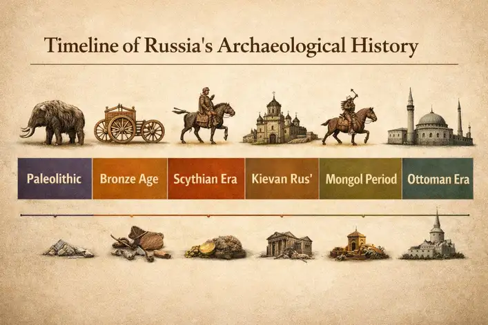
A Brief Historical Timeline of Russia
Russia’s archaeological chronology begins far before written history, with Paleolithic occupations in places such as Kostenki, Sungir, and the Altai that document early modern humans, other hominin groups, and sophisticated mortuary behavior. By the Bronze Age, fortified settlements in the southern Urals and adjacent steppe zones indicate more complex planning, metallurgy, and regional interaction. The Iron Age added kurgan traditions, ritual deposits, and northern sacrificial complexes, while southern regions participated in wider Black Sea exchange networks shaped by Greek colonies and steppe powers.
In late antiquity and the early medieval centuries, settlement patterns became increasingly tied to river routes, commercial nodes, and emerging political centers. Places such as Staraya Ladoga and Gnezdovo illuminate the formation of trade systems linking Scandinavia, the Baltic, the Volga, and Byzantium, while Volga Bulgar and later Golden Horde centers reflect the growing importance of Islamic and steppe-connected urban life in the middle Volga. The historic sites in Russia that survive from these centuries are especially useful because they show how local societies absorbed outside influences without losing regional distinctiveness.
The timeline is also globally important because discoveries in Siberia reshaped the human story itself. For readers who want a concise account of how one Altai cave changed debates about human origins, National Geographic’s account of the Denisovan finger-bone discovery offers a helpful overview grounded in the Denisova evidence. In other words, Russia’s archaeological chronology does not sit at the margins of world history; in several periods, it sits near the center of it.

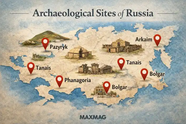
Denisova Cave: A Landmark Among the Archaeological Sites in Russia
- Location: Altai Krai, southern Siberia
- Period / Civilization: Middle Paleolithic to later prehistoric occupations
- Type of Site: Cave habitation and paleoanthropological site
- Why It Matters: It produced evidence for Denisovans, Neanderthals, and later modern humans in one of the world’s most important prehistoric sequences.
Denisova Cave is one of the most consequential prehistoric sites ever excavated on Russian territory because it preserves a long stratified sequence of occupation in the Altai Mountains. Used intermittently over tens of thousands of years, the cave offered shelter, workable stone, and access to migration routes that linked steppe, forest, and mountain environments. Its importance lies not in monumental architecture, but in accumulation: sediments, tools, faunal remains, ornaments, and rare fragments of bone that captured the presence of different hominin groups. Within the wider story of Archaeological Sites in Russia, Denisova stands out as a place where local excavation transformed global evolutionary history. What might have remained a remote cave in regional terms became a site that forced scholars to redraw the map of human ancestry.
Its distinctive feature is the combination of deep stratigraphy and exceptionally high scientific yield. Excavations produced stone tools, animal remains, personal ornaments, and, most famously, the tiny human fragments whose DNA revealed the existence of the Denisovans. Subsequent analysis also identified a first-generation hybrid individual with a Neanderthal mother and Denisovan father, a finding that dramatically strengthened evidence for interbreeding among hominin groups. The site’s chronology has been refined through radiocarbon dating, sediment analysis, and ancient DNA work, and debate continues over how specific artifact layers should be assigned to different populations and time horizons.
What Denisova reveals is not only that multiple human groups reached Siberia, but that they occupied and reused the same landscape under changing climatic conditions. The cave helps scholars reconstruct subsistence, mobility, and technological adaptation over very long spans, while also reminding readers that the prehistoric world was more entangled than older linear models allowed. It remains a focal point for ongoing research, and because new methods keep extracting information from old sediments, its relevance continues to grow. Few sites better demonstrate how a small fragment can alter humanity’s biggest questions.
Kostenki-Borshchyovo Archaeological Complex
- Location: Voronezh Oblast, along the Don River
- Period / Civilization: Upper Paleolithic
- Type of Site: Open-air settlement complex
- Why It Matters: It preserves some of the most important evidence for early modern human occupation in Eastern Europe.
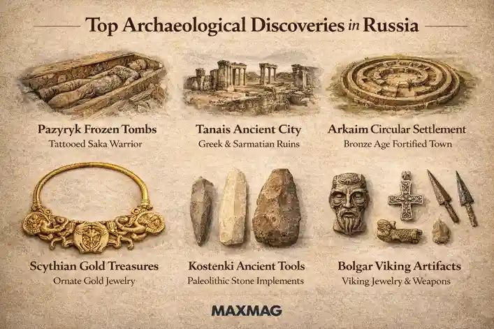
Kostenki-Borshchyovo refers to a cluster of Upper Paleolithic localities on terraces above the Don River, where repeated occupation created one of Eurasia’s classic early human research zones. These sites were used by hunter-gatherer groups who exploited riverine resources, game movement, and access to raw materials in a landscape that could support seasonal or recurring settlement. The complex matters because it anchors discussions about the timing, spread, and behavior of early modern humans in Eastern Europe. In the broader constellation of Archaeological Sites in Russia, Kostenki shows that open-air settlements can be as historically decisive as caves when preservation and stratigraphy align.
Its distinctive features include preserved habitation traces, hearths, pits, rich lithic assemblages, bone tools, and in some cases structures interpreted as dwellings built with mammoth bone. Excavations at several Kostenki localities produced ornaments, blades, faunal remains, and volcanic ash layers that helped with broader chronological comparisons. Some dates and cultural attributions have been debated, especially where very early occupations were proposed, but the complex is unquestionably central to research on Upper Paleolithic lifeways, technology, and symbolic behavior. Few river-valley sites in the region offer such a dense concentration of evidence.
Kostenki illuminates daily life at a human scale: repeated camp use, tool production, food processing, and the practical organization of space in cold environments. It also helps scholars explore how early groups planned movement, reused known locations, and embedded knowledge of landscape into survival strategies. The long research history gives the site present-day importance as well, because new excavations regularly revisit older conclusions with improved dating and environmental methods. It matters today not because it offers spectacle, but because it preserves the texture of prehistoric decision-making.
Sungir
- Location: Near Vladimir, northeast of Moscow
- Period / Civilization: Upper Paleolithic, roughly 34,000 years ago
- Type of Site: Burial and habitation site
- Why It Matters: It contains some of the richest early modern human burials known anywhere in Eurasia.
Sungir is a Paleolithic site whose fame rests above all on its burials, but its significance extends far beyond funerary display. Occupied by Upper Paleolithic hunter-gatherers, it preserves evidence for settlement activity as well as elaborate mortuary practice near what is now Vladimir. The site speaks to a society capable of investing enormous labor and symbolic meaning in burial, even within a mobile or semi-mobile world. Among Archaeological Sites in Russia, Sungir is one of the clearest reminders that deep prehistory was not socially simple merely because it was technologically early.
The most important discoveries are the graves themselves: adults and children interred with thousands of carefully shaped ivory beads, spears, ornaments, and other grave goods. The paired child burial in particular has long attracted scholarly attention because of the extraordinary richness of its offerings and the questions it raises about status, kinship, and ritual. Analysis of human remains, grave arrangement, and associated artifacts has supported new work on health, mobility, and social differentiation. Researchers have also debated chronology, genetic relationships, and the exact social meanings behind the funerary display, which is one reason the site remains intellectually active.
Sungir reveals a world in which symbolic life, craftsmanship, and social signaling were already deeply developed. The labor required to produce thousands of beads alone implies planning, skill, and shared cultural values. The site also challenges assumptions that hierarchy or ceremonial elaboration emerged only much later in settled agricultural societies. Today, Sungir remains central to public and scholarly discussions of what makes us recognizably human, because it preserves not only bodies, but intention, memory, and care in material form.
Arkaim
- Location: Chelyabinsk Oblast, southern Urals
- Period / Civilization: Middle Bronze Age, commonly linked to the Sintashta horizon
- Type of Site: Fortified settlement
- Why It Matters: It preserves a striking example of planned Bronze Age settlement and social organization in the steppe-forest frontier.
Arkaim is a circular fortified settlement discovered in the southern Urals, where its planned layout immediately made it one of the most discussed Bronze Age sites in the region. Usually associated with the broader Sintashta cultural horizon, it belonged to communities that combined herding, metallurgy, and fortified living in a landscape shaped by both mobility and regional competition. The site’s importance lies in its design: Arkaim was not an accidental aggregation of houses, but a deliberately organized place with defensive logic and internal order. In the story of Archaeological Sites in Russia, it represents an early experiment in community planning, authority, and controlled space.
Its distinctive features include concentric walls, radial housing arrangements, entrances designed with defensive considerations, and evidence for craft and domestic activity within the settlement. Excavations uncovered ceramics, metallurgical traces, animal remains, tools, and building evidence that helped scholars reconstruct both architecture and routine life. Because the site became widely known outside academic circles, it has also attracted speculative interpretations, but the archaeological value is strongest when grounded in evidence: planned fortification, production, and regional interaction. It remains essential to debates about Bronze Age warfare, social complexity, and early chariot-era cultures in the wider Eurasian steppe.
Arkaim reveals a society balancing openness and protection, pastoral mobility and fixed investment. It suggests households coordinated within a larger communal plan and that defense, craft production, and domestic life were physically integrated rather than separated. The site is also a preservation lesson, since it was famously saved from destruction after public attention helped protect it. That rescue gives Arkaim a strong present-day relevance: it shows how heritage can survive when scholarship, public pressure, and policy meet at the right moment.
Pazyryk Burial Mounds
- Location: Altai Republic
- Period / Civilization: Iron Age, often associated with Scythian-related nomadic groups
- Type of Site: Kurgan cemetery
- Why It Matters: Frozen burial conditions preserved organic materials rarely found in steppe archaeology.
The Pazyryk burial mounds are among the most famous kurgan sites in Inner Asia because the Altai’s cold conditions preserved objects that normally vanish from the archaeological record. Built by Iron Age nomadic elites connected to the wider Scythian world, these barrows served as burial chambers, political statements, and ritual landscapes all at once. Their historical role is especially important because mobile societies often leave fewer permanent settlements than urban cultures, making burials a crucial source for reconstructing status, ideology, and material culture. Within Archaeological Sites in Russia, the Pazyryk mounds give rare texture to a world often described too abstractly.
Their distinctive feature is permafrost preservation. Excavators recovered textiles, woodwork, horse gear, tattooed human remains, felt objects, and the celebrated carpet often associated with high levels of craftsmanship and long-distance exchange. Such finds transformed understanding of steppe artistry, elite display, and the technical sophistication of mobile societies. The burials also provide evidence of horses, vehicles, and ceremonial staging. Interpretation is still carefully debated, especially when linking imagery to ethnic labels or broad civilizational narratives, but the archaeological importance of the preserved objects themselves is not in doubt.
These kurgans reveal a social world structured by rank, ritual, and mobility rather than by cities. They show that wealth, aesthetic refinement, and symbolic order could flourish in nomadic contexts, and that burial practice functioned as a theater of political identity. Their modern relevance is twofold: they remain iconic for museum scholarship, and they are deeply vulnerable to looting, climate shifts, and illicit antiquities markets. The Pazyryk mounds matter because they preserve the fragile evidence of a society that was powerful, connected, and anything but peripheral.
Tanais
- Location: Rostov Oblast, near the mouth of the Don
- Period / Civilization: Hellenistic and later Bosporan-era occupation
- Type of Site: Ancient city and trading settlement
- Why It Matters: It records sustained contact between Greek colonial traditions and steppe populations.
Tanais was an ancient city at a strategic point near the Don delta, where river access and Black Sea connectivity made it a natural exchange hub between the Greek world and inland steppe zones. Founded in the Hellenistic era and later integrated into wider Bosporan political frameworks, it functioned as a commercial and cultural frontier settlement. Its historical role is especially valuable because it helps scholars examine how colonial urbanism adapted to a contact zone rather than reproducing a Mediterranean city unchanged. In the wider field of Archaeological Sites in Russia, Tanais demonstrates how southern territories participated in cross-cultural systems far larger than any single local polity.
Excavations have revealed fortification lines, street layouts, domestic structures, inscriptions, ceramics, imported goods, coins, and evidence of trade activity. These finds make Tanais distinctive as a place where textual, architectural, and material evidence can be read together. The site has also yielded clues to episodes of destruction, rebuilding, and shifting political control, allowing scholars to trace instability alongside exchange. Rather than offering a simple narrative of Greek dominance, the evidence points to negotiation, adaptation, and local variation at the edge of several cultural worlds.
Tanais reveals daily life shaped by commerce, language contact, and frontier pragmatism. Foodways, storage practices, imported wares, and urban defenses all point to a community that depended on both outside connections and local resilience. The site also helps modern readers understand that the northern Black Sea was never merely a distant fringe of classical history. It was a zone where Mediterranean habits were transformed by steppe realities, and that makes Tanais historically valuable well beyond regional interest.
Phanagoria
- Location: Taman Peninsula, Krasnodar Krai
- Period / Civilization: Archaic Greek through Bosporan and later occupations
- Type of Site: Ancient city, port, and necropolis complex
- Why It Matters: It was one of the major urban centers of the Bosporan Kingdom.
Phanagoria, founded by Greek colonists on the Taman Peninsula, developed into one of the principal cities of the Bosporan Kingdom and a major node in Black Sea commerce. Its location gave it access to maritime routes, agricultural hinterlands, and interaction with inland populations, making it both a port and a political center. The site matters because it preserves evidence for long urban continuity in a region often framed only through imperial or frontier narratives. As one of the most important Archaeological Sites in Russia, Phanagoria broadens the country’s archaeological image beyond prehistory and medievality into a deeply connected classical world.
Its distinctive features include urban architectural remains, sections of necropolis, inscriptions, ceramics, coins, public structures, and traces of harbor-related activity. Underwater archaeology has also contributed to understanding parts of the settlement and its changing shoreline. Excavations over many seasons have produced evidence tied to governance, trade, religion, and everyday domestic life, helping scholars reconstruct an urban center with both local and international dimensions. Because the site evolved over centuries, interpretation requires careful phasing, but that complexity is precisely what makes it so valuable.
Phanagoria reveals a city where administration, ritual, and commerce were tightly linked. It shows how imported cultural forms were maintained, modified, and localized in a mixed environment shaped by the Black Sea and adjacent steppe. It also contributes to the archaeological heritage of Russia by preserving a long record of urban life that resists simplistic East-West divisions. The site matters now because it keeps reminding readers that Russia’s past includes port cities and classical diplomacy as well as forests, forts, and frontiers.
Staraya Ladoga
- Location: Leningrad Oblast, on the Volkhov River
- Period / Civilization: Early medieval, especially 8th-10th centuries
- Type of Site: Settlement, trading center, and fortified locale
- Why It Matters: It is one of the earliest major centers tied to the emergence of the Rus world.
Staraya Ladoga occupies a key place in early medieval history because it sat on an important river route linking the Baltic to inland waterways and, ultimately, to broader trade systems. Archaeology suggests it functioned as a settlement and exchange center used by a mixed population that included Scandinavian, Slavic, and Finnic elements. Its historical role is crucial not because it offers a single origin myth, but because it provides material evidence for the multiethnic commercial environment from which early Rus power developed. The site gives form to a period too often narrated only through chronicles.
Excavations have uncovered wooden structures, craft debris, imported objects, workshops, fortification traces, and layers that speak to repeated rebuilding in a riverine settlement. Finds related to metalworking, trade, and domestic production make the site distinctive as a lived center rather than a merely symbolic one. Archaeologists continue to debate aspects of chronology, political status, and the relative weight of Scandinavian versus local traditions, but those debates reflect the richness of the evidence rather than weakness in it. The layered nature of the site helps scholars track practical adaptation to commerce and risk.
Staraya Ladoga reveals a world organized by waterways, exchange, and negotiation. It helps explain how communities formed around commerce before later states formalized authority, and how identity in such places was often hybrid, transactional, and regionally grounded. Present-day relevance is strong because the site is central to discussions of early state formation and cultural contact in northern Eastern Europe. Its importance lies in showing how large political histories begin in small, durable traces of work and movement.
Gnezdovo
- Location: Near Smolensk, on the upper Dnieper
- Period / Civilization: 9th-10th centuries
- Type of Site: Settlement and mound cemetery complex
- Why It Matters: It preserves one of the largest early medieval burial and trading landscapes in the region.
Gnezdovo is an extensive early medieval complex of settlement traces and burial mounds near Smolensk, strategically placed on river routes that linked northern and southern exchange systems. It is especially important for understanding the commercial, military, and social worlds of the 9th and 10th centuries, when movement along the Dnieper corridor carried people, silver, and cultural forms across wide distances. The site’s scale suggests it was not a marginal outpost, but a major node in a broader network connecting Baltic, steppe, and Byzantine spheres.
Its distinctive features include large numbers of kurgans, craft evidence, imported objects, weapons, ornaments, and material tied to both elite and everyday activity. Excavated burials have yielded items associated with trade and status, while settlement remains help reconstruct production and habitation. Scholars have long debated the exact political relation between Gnezdovo and nearby Smolensk, as well as its ethnic composition, but the importance of the site as a major early medieval center is clear. It is one of the best places for tracing how exchange and authority interacted before later urban consolidation.
Gnezdovo reveals that early medieval society in the region was structured by routes as much as by borders. Burial customs, imported goods, and craft remains all point to a community deeply involved in circulation, brokerage, and negotiation. The site still matters because it preserves evidence for how local life was transformed by long-distance exchange without becoming culturally uniform. In that sense, Gnezdovo is a reminder that connected worlds are not a modern invention.
Bolgar Historical and Archaeological Complex
- Location: Republic of Tatarstan, on the Volga River
- Period / Civilization: Volga Bulgar and later Golden Horde phases
- Type of Site: Urban archaeological complex
- Why It Matters: It records the political, commercial, and religious development of a major Volga center.
Bolgar was one of the most important urban centers on the middle Volga, associated first with Volga Bulgaria and later with the Golden Horde’s wider world. Positioned on a major river artery, it flourished through trade, taxation, craft activity, and political significance in a zone that connected steppe routes, forest regions, and Islamic exchange networks. Its historical role is vital because it demonstrates that medieval urban sophistication in today’s Russia was not confined to the Slavic north or the western river corridors, but also flourished in Turkic and Islamic settings along the Volga.
Archaeological work at Bolgar has revealed foundations, urban layouts, craft areas, imported wares, coins, and architectural remains associated with religious and administrative life. The complex is distinctive because it combines standing and excavated evidence, allowing scholars to connect site planning with broader historical development. Finds from ceramics to metalwork show both local production and long-distance commercial links. Because the city changed over time, archaeologists read it as a layered urban landscape rather than a frozen single moment, which is precisely what makes it so historically rich.
Bolgar reveals a society shaped by trade, literacy, faith, and regional diplomacy. It helps readers see the Volga not as a remote interior, but as a major civilizational corridor. The site’s present-day relevance is reinforced by strong heritage recognition and by its continuing role in conversations about plural historical identities within Russia. Bolgar matters because it anchors medieval statecraft and cultural exchange in a material landscape that still commands respect.
Ust-Polui
- Location: Near Salekhard, Yamalo-Nenets Autonomous Okrug
- Period / Civilization: Early Iron Age
- Type of Site: Ritual and habitation complex
- Why It Matters: It is one of the most important archaeological sites for understanding early societies in the Arctic zone.
Ust-Polui is an Early Iron Age site near the lower Ob region whose northern location makes it exceptionally important for Arctic archaeology. Rather than fitting the standard model of a large urban center or fortified settlement, it appears to have combined ritual significance with repeated human activity in a high-latitude environment where preservation can be unusually informative. Its historical role lies in showing that complex symbolic behavior, exchange, and carefully structured use of space were present in Arctic societies that outsiders once misunderstood as archaeologically invisible.
The site’s distinctive evidence includes bone, antler, metal, animal remains, and artifacts interpreted in relation to ritual activity and subsistence. Excavations have highlighted faunal assemblages and material traces that help scholars reconstruct seasonal practices, hunting economies, and ceremonial behavior. Because northern preservation conditions can favor organic survival, the site provides a richer picture of lifeways than many comparable contexts farther south. Interpretation remains cautious, especially where ritual meaning is inferred from deposition patterns, but the combination of artifacts and context gives Ust-Polui unusual explanatory power.
Ust-Polui reveals how people organized life, belief, and resource use in a demanding Arctic environment. It broadens the geographic imagination of Russian archaeology by showing that the far north was not an empty edge, but a lived and culturally meaningful world. The site remains highly relevant today because climate change and thawing ground can threaten exactly the kinds of preserved materials that make northern archaeology so valuable. Its lesson is simple and profound: fragile landscapes can hold durable memory.
Por-Bajin
- Location: Tuva Republic, on an island in Lake Tere-Khol
- Period / Civilization: 8th century, often linked to the Uyghur Khaganate
- Type of Site: Walled complex
- Why It Matters: It is a rare high-profile example of early medieval monumental construction in southern Siberia.
Por-Bajin is a dramatic rectilinear walled complex in Tuva whose isolated island setting has made it one of the most visually striking archaeological places in southern Siberia. Commonly associated with the Uyghur Khaganate, the site belongs to a period when steppe empires built not only mobile political systems but also formal architectural spaces with administrative, ceremonial, or residential functions. Its historical role is important because it captures a moment when imperial ambition was translated into monumental design far from familiar urban centers.
Its distinctive features include a large enclosure plan, internal building remains, rammed-earth construction, and an unusual combination of elite scale with environmental isolation. Scholars have debated whether it functioned primarily as a palace, monastery, ceremonial center, seasonal residence, or something more limited in duration. Scientific work, including environmental and chronological analysis, has helped refine discussion of why the complex may have been used only briefly. That mixture of architectural clarity and interpretive uncertainty is part of what keeps Por-Bajin compelling to archaeologists.
Por-Bajin reveals the reach of early medieval political imagination across Inner Asia and southern Siberia. It shows that architecture on the steppe could be formal, planned, and ideologically charged, even when its function remains partly unresolved. The site’s present-day significance lies in the way it invites careful interpretation rather than simplistic certainty. Sometimes the most valuable archaeological lesson is not a complete answer, but a better-framed question about power, landscape, and intention.
What These Sites Reveal About Ancient Life in Russia
Taken together, these sites make the ancient civilizations of Russia visible through ordinary evidence as much as extraordinary finds. They show that daily life was organized around seasonality, risk, and access to resources, but also around symbols, hierarchy, and memory. Hearths, refuse layers, workshops, graves, walls, corrals, ritual deposits, and imported goods all suggest that communities were constantly balancing immediate survival with longer-term social meaning.
Archaeological Sites in Russia collectively reveal that trade was rarely a simple matter of moving objects from one place to another. Exchange changed diets, prestige systems, technologies, and local identities. In some regions, imported ceramics or coins mark urban integration; in others, exotic materials in burials point to elite networks or gift exchange. Religion, too, becomes visible through what people built, how they buried the dead, where they deposited valued objects, and how they marked sacred or protected space in the landscape.
These places also clarify social hierarchy. Rich graves at Sungir and the Pazyryk mounds, planned enclosures at Arkaim and Por-Bajin, and urban administrative traces at Phanagoria or Bolgar all point to unequal access to labor, authority, and display. Yet archaeology also preserves the less glamorous foundations of life: food processing, hunting, herding, craft production, storage, and domestic repair. That combination is what gives the evidence its human force. It lets us see power, but it also lets us see the routines that made power possible.
Preservation Challenges Facing Archaeological Sites in Russia
Protecting Archaeological Sites in Russia is especially difficult because the sites are spread across enormous distances and exposed to very different threats. Southern settlements can face agricultural pressure, construction, and illicit digging, while northern and high-altitude contexts face thaw, erosion, and rapidly changing environmental conditions. Even where legal protection exists, monitoring is uneven, and remote locations can make both stewardship and emergency response difficult.
Some of the greatest risks are not dramatic acts of destruction but slow losses: shoreline change, repeated freeze-thaw cycles, unmanaged visitation, underfunded storage, and the quiet disappearance of context when objects are removed without proper recording. For a concise example of why new excavations in Siberia still matter to global scholarship, Smithsonian Magazine’s report on research at Chagyrskaya Cave illustrates how fresh fieldwork in the Altai can reshape big historical questions. That is precisely why preservation is not a niche concern for specialists; once context is lost, interpretation narrows forever.
Museums, regional heritage offices, archaeologists, and research institutes all play a role in responsible stewardship, but so do excavation ethics, local communities, and long-term funding structures. Conservation is not only about keeping walls standing. It is about documenting layers, stabilizing fragile materials, publishing data, and protecting the conditions that let future researchers ask better questions than today’s scholars can. Cultural memory survives best when preservation is treated as an ongoing public responsibility rather than a one-time rescue.
The Archaeological Legacy of Russia
The most important legacy of these places is intellectual as much as monumental. Archaeological Sites in Russia reveal that the country’s long development was shaped not by a single uninterrupted civilizational line, but by repeated encounters among foragers, pastoralists, traders, settlers, ritual specialists, and political elites. That broader view enriches national history because it restores plurality where later narratives often prefer neat beginnings and singular identities.
Archaeological Sites in Russia also matter because they connect local landscapes to global questions: human evolution, mobility across Eurasia, frontier urbanism, early state formation, and the material expression of belief and authority. In that sense, they are not only evidence of Russia’s past; they are part of the shared archive of world history. They also remain among the most important cultural landmarks of Russia, precisely because they carry meanings that are scholarly, regional, and civic at the same time.
When preserved and interpreted responsibly, these sites help modern audiences think more clearly about continuity and change. They remind us that identities are built over long durations, often through contact and adaptation rather than isolation. Their legacy is not nostalgia. It is perspective.
Conclusion
Russia is archaeologically important because its landscapes preserve unusually wide evidence for human life across deep time, from Paleolithic burials and Altai cave sequences to Bronze Age planning, Black Sea urbanism, Volga political centers, and early medieval trade networks. No single site can summarize that range, but together Archaeological Sites in Russia make the country’s deeper history visible in concrete, testable, and often surprising ways. They show that the Russian past was never a narrow corridor to a later state; it was a broad and changing field of experiments in survival, exchange, ritual, and power.
That is why preservation, publication, and historically responsible interpretation matter so much. Archaeology gives readers access not only to rulers and borders, but to households, makers, travelers, herders, mourners, and communities who left behind material evidence of how they understood their world. To study these places well is to treat the past as something more than legend or prestige. It is to protect a record of human possibility written into soil, bone, timber, metal, and stone.
Q1: What is the most globally significant archaeological site in Russia?
Q2: Which Russian site is best known for elite prehistoric burials?
Q3: Are Archaeological Sites in Russia limited to prehistoric caves and burials?
Q4: Why is Arkaim important?
Q5: What are the biggest threats to Russian archaeological heritage today?
Q6: Why should non-specialists care about these sites?