Germany is often approached through its modern political history, but the land beneath its fields, river valleys, and old urban centers preserves a far longer human story. Archaeological Sites in Germany reveal how Roman administrators, Celtic elites, Bronze Age ritual communities, Viking merchants, and early medieval builders all left material traces that still shape historical research today. Read closely, these landscapes are not isolated monuments but connected archives of movement, conflict, belief, and adaptation across thousands of years.
What makes Germany especially compelling is the way its evidence spans radically different eras without breaking the thread of continuity. From fortified Iron Age hilltops to Roman frontier towns and from ceremonial enclosures to early trading hubs, the country offers a dense sequence of historic sites in Germany that help scholars track changing forms of power, settlement, and exchange. In editorial terms, the story is larger than stones in the ground: Archaeological Sites in Germany illuminate how central Europe became a crossroads where empires met local societies, and where local societies repeatedly transformed the legacy of empire.
That breadth also makes the German record unusually useful for general readers. Prehistory, Roman expansion, post-Roman transformation, and the rise of early medieval trade can all be studied within one national frame, yet each site retains its own texture, local ecology, and interpretive challenge. The result is a landscape that rewards slow attention and careful preservation rather than quick, checklist-style tourism.
Why Germany Matters Archaeologically
Germany matters archaeologically because it sits at the hinge of northern, western, and central Europe. Rivers such as the Rhine, Danube, Elbe, and Weser created corridors for travel, commerce, military advance, and cultural exchange, while uplands, forests, and coastal routes generated regional differences that are legible in settlement patterns and material culture. This position made the area neither a single ancient state nor a blank frontier; it was instead a contact zone where successive communities negotiated identity, authority, and survival.
Its archaeological record is distinctive for range. The territory preserves Paleolithic cave use, Neolithic ritual architecture, Bronze Age prestige goods, Iron Age princely seats, Roman military infrastructure, and early medieval emporia. That breadth allows scholars to compare long-term changes in technology, diet, burial custom, warfare, and religion. It also helps correct older myths that treated central European societies as passive margins waiting to be shaped by Rome or later kingdoms.
Archaeology in Germany is therefore not just about finding famous objects. It is about reconstructing how communities organized labor, managed landscapes, marked sacred space, and responded to political pressure. Every trench, posthole, coin scatter, and burial assemblage adds nuance to the deep history of a region that has long stood at the center of European transformation.
Archaeological Sites in Germany and the Deep Historical Record
The density of Germany’s archaeological landscape is meaningful because it reflects long occupation rather than a single golden age. Settlement repeatedly clustered along fertile plains, navigable rivers, and defensible heights, producing a patchwork of communities that were connected enough to exchange goods yet diverse enough to leave sharply different material signatures. Seen together, these sites document continuity through change: ritual spaces become memory landscapes, strategic crossings become battlegrounds, and temporary frontier installations can evolve into urban frameworks.
This deeper pattern is especially visible when one compares prehistoric enclosures, Iron Age fortifications, Roman installations, and medieval trading centers. Each belongs to a different social order, but all speak to the same enduring question: how did people use geography to secure food, power, protection, and meaning? A useful broader frame appears in National Geographic’s reporting on the Tollense battlefield, which shows how one German valley can reshape assumptions about Bronze Age conflict on a continental scale.
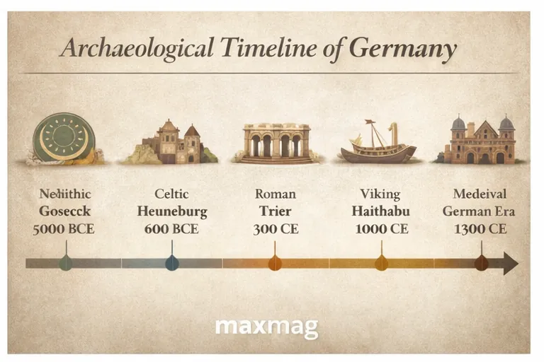
A Brief Historical Timeline of Germany
Germany’s archaeological sequence begins deep in prehistory, from Paleolithic occupation to the farming transitions of the Neolithic, when enclosed ritual spaces and more settled communities became increasingly visible in the record. By the Bronze Age, metalworking, long-distance exchange, elite display, and specialized ceremonial practices were changing how communities expressed rank and cosmology. The Iron Age then brought larger fortified centers and richly furnished burials that reveal the political complexity of the ancient civilizations of Germany, especially in areas linked to Hallstatt and La Tene traditions.
From the late first century BCE onward, Rome pressed strongly into the western and southern parts of the region, building forts, roads, administrative centers, and market spaces even as territories beyond direct control remained home to varied local groups. The Roman frontier, and the conflicts around it, created one of the most intensively studied archaeological zones in Europe. After Rome’s formal retreat from some northern and eastern areas, settlement did not vanish; instead, the material record shows adaptation, reuse, and new political formations across late antiquity and the early medieval period.
By the Viking Age and high Middle Ages, northern Germany contained major commercial hubs and defensive systems tied to Baltic and North Sea networks. Across all these periods, the archaeological landscape accumulated rather than reset, which is why sites from very different eras can still be read together as parts of one long, layered story.
Porta Nigra: A Landmark Among the Archaeological Sites in Germany
- Location: Trier, Rhineland-Palatinate
- Period / Civilization: Roman Empire, 2nd century CE
- Type of Site: City gate and urban fortification
- Why It Matters: It is the best-preserved Roman city gate north of the Alps and a key witness to the scale of Roman Trier.
Built in the late second century CE, the Porta Nigra formed part of the monumental defenses of Augusta Treverorum, the Roman city that became one of the empire’s most important centers north of the Alps. Its surviving mass gives a sense of Trier’s political weight during late Roman rule, when the city served as an imperial residence and administrative hub. The gate was not an isolated ornament: it controlled movement, embodied imperial authority, and signaled that Roman urban planning had taken deep root in the Moselle region. Among the most studied Archaeological Sites in Germany, it anchors the story of how Rome translated military reach into durable civic infrastructure. Even after antiquity, the structure remained meaningful, later reused and adapted in Christian contexts rather than simply abandoned.
The gate’s distinctive feature is its extraordinary survival. Constructed from massive sandstone blocks fastened without mortar, it still demonstrates the engineering confidence of Roman monumental building. Archaeological study has clarified not only the gate itself but also its relationship to the wider street system, nearby walls, and the layered transformations that followed. Its medieval conversion into a church complex, associated with the figure of Simeon, protected much of the Roman core from spoliation. That later reuse is crucial: the monument was preserved not by accident but because successive societies assigned it new purpose, allowing researchers to trace both Roman design and post-Roman reinterpretation in one structure.
Porta Nigra reveals more than Roman military order. It points to a fully urbanized world of taxation, movement, ceremony, trade, and legal administration in which city gates regulated both people and symbolism. The monument also reminds modern audiences that preservation often depends on continuity of use, however altered that use becomes. Today it stands at once as a Roman survival, a medieval intervention, and a modern heritage site whose layered history challenges simple narratives of rise and fall. That combination of durability, adaptation, and civic memory is why the gate still matters.
Saalburg Roman Fort
- Location: Near Bad Homburg, Hesse
- Period / Civilization: Roman Empire, High Imperial period
- Type of Site: Frontier fort on the Upper Germanic-Rhaetian Limes
- Why It Matters: It helps explain how Rome organized surveillance, logistics, and daily life on a frontier.
Saalburg was one installation in the vast frontier system known as the Upper Germanic-Rhaetian Limes, but it has become one of the clearest places to understand Roman border management in central Europe. The fort housed auxiliary troops rather than legionaries, which is historically important because auxiliaries were the practical backbone of everyday frontier control. They patrolled routes, monitored movement, conveyed messages, and linked local settlements to imperial authority. As one of the most interpretable Archaeological Sites in Germany, Saalburg demonstrates that the Roman frontier was not a single wall dividing civilization from wilderness; it was a managed zone of watchfulness, bureaucracy, commerce, and negotiated contact.
The site’s importance lies partly in excavation history and partly in legibility. Archaeological work identified barracks, gates, headquarters buildings, baths, and associated civilian areas, offering unusually concrete evidence for how an imperial fort functioned as both military compound and social ecosystem. Finds from the area have included tools, pottery, writing implements, and small everyday objects that make the fort feel less like an abstract line on a map and more like a lived place. Because the site was reconstructed in the modern era, scholars can also discuss the difference between original remains and later didactic rebuilding, an issue that matters for public archaeology.
Saalburg’s human story is one of routine discipline rather than dramatic conquest. Soldiers ate, repaired gear, wrote letters, bathed, worshipped, and interacted with traders and families in a landscape where frontier identity was constantly negotiated. The fort therefore reveals how empire depended on repetitive labor and supply systems as much as on battlefield victories. Its present relevance lies in showing that borders are built through infrastructure and administration, not slogans alone. That makes Saalburg invaluable for anyone trying to understand Roman power in practical terms.
Colonia Ulpia Traiana and the Xanten Archaeological Park
- Location: Xanten, North Rhine-Westphalia
- Period / Civilization: Roman Empire, mainly 1st-3rd centuries CE
- Type of Site: Roman colonia and urban archaeological complex
- Why It Matters: It offers one of the clearest large-scale pictures of Roman urban life in the Rhineland.
At Xanten, the remains of Colonia Ulpia Traiana preserve the footprint of a Roman city laid out with roads, public buildings, entertainment structures, and residential zones. Founded under imperial authority in the early second century CE, it represents Rome at its most urban and confident on the Rhine frontier. Unlike an isolated fort, a colonia was meant to embody civic life: it housed administrators, merchants, craftspeople, veterans, and local populations incorporated into Roman structures of law and exchange. For readers trying to picture the scale of ancient ruins in Germany, Xanten offers one of the strongest examples of a planned Roman city that was both provincial and fully connected to imperial systems.
Excavation and presentation at Xanten have revealed amphitheater remains, baths, temple zones, harbor-related evidence, domestic areas, and extensive infrastructure beneath later deposits. This combination makes the site uniquely valuable for studying urban planning and social differentiation. Archaeologists can ask not just what stood there, but how neighborhoods functioned, where commerce clustered, and how public spectacle fit into provincial life. Because the archaeological park integrates original remains with interpretive reconstruction, it also gives visitors and researchers a rare chance to understand scale, movement, and architectural rhythm without losing sight of the evidence base.
Xanten reveals a world in which Roman identity was manufactured locally through architecture, ritual, trade, and law. It shows how a frontier zone could also be a place of comfort, consumption, and urban ambition. The city matters today because it corrects the stereotype of Roman Germany as little more than camps and battle lines; it was also a place of markets, theaters, households, workshops, and planned civic order. That fuller picture is why Xanten remains indispensable.
Kalkriese Battlefield
- Location: Near Osnabruck, Lower Saxony
- Period / Civilization: Early Roman Imperial era, linked to the defeat of Varus in 9 CE
- Type of Site: Battlefield landscape
- Why It Matters: It offers major physical evidence for one of Rome’s most consequential frontier disasters.
Kalkriese is widely associated with the catastrophic Roman defeat traditionally tied to the Varian disaster of 9 CE, when forces under Publius Quinctilius Varus were destroyed in hostile territory east of the Rhine. While scholars continue to debate the exact relationship between archaeological remains and the literary accounts, the site’s significance is unquestionable. It preserves a battlefield landscape rather than a single monument, allowing historians to think in terms of terrain, movement, vulnerability, and ambush. Within the wider constellation of Archaeological Sites in Germany, Kalkriese stands out because it captures a moment when imperial expansion met decisive resistance and strategic overreach had lasting consequences.
The site’s distinctive features include distributions of Roman military equipment, coins, and associated finds spread across a corridor shaped by boggy ground and rising terrain. Excavations have identified evidence consistent with a constricted movement path and with violent conflict rather than orderly occupation. Coin finds, especially those tied to the Augustan period, have been central to interpretation. Yet the site is valuable precisely because it forces careful method: archaeology can strengthen, complicate, or challenge textual history, and Kalkriese has become a model case in how battlefield archaeology and classical sources are brought into dialogue.
What Kalkriese reveals is not only military catastrophe but the limits of imperial certainty. Armies move through landscapes shaped by weather, local knowledge, and morale, and even a superpower can become fragile when supply, terrain, and command break down. Today the site matters because it turns a famous historical episode into a material, human problem: people marched here, fought here, died here, and left traces that still reshape historical interpretation. That is why Kalkriese remains one of Europe’s most important conflict landscapes.
Heuneburg
- Location: Near Herbertingen, Baden-Wurttemberg
- Period / Civilization: Early Iron Age, Hallstatt culture
- Type of Site: Fortified hilltop settlement and elite center
- Why It Matters: It is one of the key princely sites for understanding early complex society north of the Alps.
Heuneburg was an elite fortified center occupied during the early Iron Age, especially in the 6th century BCE, and it has long been central to debates about early urbanism north of the Alps. Positioned above the Danube, the site controlled movement and projected authority in a landscape where trade links, political hierarchy, and ceremonial display were growing increasingly visible. Rather than a simple hillfort, Heuneburg functioned as a power center tied to surrounding settlements, burial mounds, and exchange networks. It matters because it demonstrates that social complexity in central Europe developed through local institutions and long-distance contact, not merely through later Mediterranean influence.
One of Heuneburg’s most distinctive features is the mudbrick wall built on a stone base, a construction method unusual for the region and suggestive of Mediterranean inspiration or interaction. Excavations have revealed dense occupation, craft production, imported goods, fortification systems, and a broader settlement zone extending beyond the hilltop core. These discoveries are crucial because they show organized labor, status differentiation, and strategic planning at a scale once underestimated in Iron Age Europe. The site therefore continues to influence scholarly debates about whether some Hallstatt centers should be described as proto-urban communities.
Heuneburg reveals a society capable of concentrating wealth, controlling routes, and displaying power through architecture and prestige goods. It sheds light on rank, craft specialization, and the politics of visibility in an era often flattened into vague “tribal” stereotypes. Its present relevance is not just regional pride but intellectual correction: it forces a more serious view of early central European political life. That is why Heuneburg still changes how the pre-Roman past is understood.
Glauberg
- Location: Hesse
- Period / Civilization: Late Iron Age, Celtic context
- Type of Site: Hillfort, ritual landscape, and elite burial complex
- Why It Matters: It is one of the most important Celtic archaeological complexes in central Europe.
Glauberg is not important because it offers one dramatic object alone, but because it combines settlement, fortification, elite burial, and a shaped ceremonial landscape in a single archaeological complex. The site flourished in the late Iron Age and has become essential for understanding how power, ritual, and memory worked in Celtic societies north of the Alps. The hilltop enclosure, surrounding earthworks, and associated graves suggest a place where political authority and ceremonial display were tightly linked. In that sense, it belongs among the most revealing Archaeological Sites in Germany for readers interested in how elite identity was performed rather than simply inherited.
The discovery most strongly associated with Glauberg is the richly furnished burial and the sandstone statue often interpreted as a representation of an elite warrior or ruler. The combination of grave goods, monumental setting, and sculptural evidence is rare and powerful. Archaeologists have also studied the processional or geometric landscape features around the site, which indicate that ceremonial movement and spatial symbolism were likely central to its use. These elements make Glauberg valuable not just for artifact display but for reconstructing a larger political and ritual environment.
Glauberg reveals a world where rank was made visible through burial, landscape design, and durable symbols of authority. It points to communities that organized labor for earthworks, crafted prestige objects, and encoded power into formal space. Today the site matters because it resists simplistic ideas of Iron Age Europe as socially thin or culturally isolated. Instead, it shows a sophisticated society staging memory, hierarchy, and belonging in ways that still speak across centuries.
Goseck Circle
- Location: Saxony-Anhalt
- Period / Civilization: Neolithic, around the 5th millennium BCE
- Type of Site: Circular enclosure and probable ritual/astronomical site
- Why It Matters: It is one of the earliest known monumental enclosures in Europe and a key site for early ritual landscapes.
Goseck Circle belongs to a much earlier world than Roman forts or Iron Age princely seats, yet it is just as important for understanding how human communities structured meaning in the landscape. Dating to the Neolithic, the enclosure consists of concentric ditches and palisades with carefully placed entrances. Its significance lies in what that arrangement implies: planning, coordinated labor, and a shared symbolic system among early farming communities. As one of the oldest monumental enclosures in the region, it demonstrates that formal sacred or ceremonial architecture in central Europe emerged long before written history and long before urban states.
Researchers have paid special attention to the enclosure’s orientations, especially the suggestion that some gateways align with solar events around the winter solstice. Interpretation remains cautious, but the possibility of astronomical or calendrical meaning has made Goseck widely discussed. Excavation has also produced evidence relevant to enclosure construction, use, and deposition, allowing archaeologists to consider whether the site functioned for ritual gathering, seasonal marking, social coordination, or several purposes at once. The site’s visibility in the modern public imagination is understandable, but its scholarly value comes from the way it ties architecture to early cosmological thinking.
Goseck reveals that ancient life was shaped not only by subsistence and shelter but by efforts to order time, community, and sacred orientation. It points to a society willing to invest labor in symbolic structure, suggesting that ritual coordination was central to social cohesion. Today, the site matters because it expands the historical imagination: even in the deep Neolithic, communities in this landscape were building with intention, memory, and celestial awareness in mind. That is an enduring reason to care.
Mittelberg and the Nebra Sky Disc Findspot
- Location: Near Nebra, Saxony-Anhalt
- Period / Civilization: Usually associated with the Bronze Age, though dating debates have existed
- Type of Site: Hilltop findspot and associated ritual landscape
- Why It Matters: It is tied to the Nebra Sky Disc, one of the most famous prehistoric finds associated with Germany.
The hill known as Mittelberg near Nebra entered global archaeological discussion because it is associated with the discovery of the Nebra Sky Disc, the bronze-and-gold object often described as one of the earliest known representations of the sky. The circumstances of discovery were deeply problematic: the disc was found by looters, which complicated context, damaged evidence, and later fueled debate about dating and association. Even so, the findspot and its surrounding landscape remain historically important. They point to a Bronze Age world in which cosmology, prestige, and metalwork could converge in a single object of extraordinary symbolic force.
The disc itself is the site’s great distinctive feature, but the broader significance lies in interpretation. Archaeologists have weighed the associated objects, the metallurgical evidence, and the compromised excavation history in order to place the artifact within a plausible cultural and chronological frame. Debate has not disappeared, and it should not be flattened. A concise public overview can be found in Smithsonian Magazine’s discussion of the Nebra Sky Disc debate, which captures why contested context matters so much in archaeology. The site is therefore a lesson in both prehistoric symbolism and archaeological method.
Mittelberg reveals how fragile knowledge can be when context is damaged, but also how much information careful scholarship can still recover. The findspot speaks to ritualized landscapes, elite objects, and the importance of celestial knowledge in Bronze Age society. It also warns that looting destroys not just legal ownership but relationships among objects, place, and meaning. Today, the site matters because it joins wonder with caution: it is a reminder that spectacular artifacts are only fully legible when their contexts are protected.
Haithabu (Hedeby)
- Location: Near Schleswig, Schleswig-Holstein
- Period / Civilization: Early medieval / Viking Age
- Type of Site: Trading settlement and emporium
- Why It Matters: It was one of the major commercial hubs of the Viking world.
Haithabu, known internationally as Hedeby, was one of the most important early medieval trading centers in northern Europe. Situated near a strategic land bridge between the North Sea and Baltic worlds, it occupied a position that made commerce efficient and politically significant. This was not merely a local market town; it was a nodal point in networks linking Scandinavia, the Frankish world, the Baltic, and beyond. In the sequence of Archaeological Sites in Germany, Haithabu is vital because it shifts the narrative from prehistory and Rome to a mercantile landscape where mobility, exchange, and cross-cultural contact defined daily life.
Excavation at Haithabu has produced house remains, harbor structures, craft debris, imported goods, weapons, personal objects, and evidence of specialized production. Such finds allow archaeologists to reconstruct not only trade routes but the texture of urban craft and commercial life in the Viking Age. The associated defenses and the relationship to nearby power structures also show that commerce and control were inseparable. Because the site is part of a UNESCO listing with nearby defenses, it can be read both as a marketplace and as a strategic statement about who controlled movement through this critical corridor.
Haithabu reveals a society in which merchants, craftspeople, sailors, and political authorities all depended on one another. Daily life here involved storage, repair, exchange, negotiation, and exposure to foreign goods and ideas. The site matters now because it demonstrates that northern Europe was deeply connected long before modern nation-states, and that Germany’s past includes major chapters in the history of maritime trade and cultural contact. That wider relevance keeps Haithabu central.
Danevirke
- Location: Schleswig-Holstein
- Period / Civilization: Early medieval, with multiple phases
- Type of Site: Defensive earthwork and fortification system
- Why It Matters: It is one of northern Europe’s most important early medieval defensive landscapes.
Danevirke is a vast defensive system built and expanded over time in the Schleswig region, and it must be understood as a landscape of power rather than a single wall. Its lines, ditches, and associated structures controlled a strategic corridor and articulated authority over movement between peninsular and continental zones. The site matters because it demonstrates large-scale collective labor in the early medieval north and because it connects military logic to political identity. Although often discussed alongside Danish history, it is also integral to the archaeological understanding of territory within present-day Germany.
Its distinctive feature is cumulative scale. Rather than a one-time construction, Danevirke was modified across centuries, which means archaeologists can study changing defensive priorities, engineering choices, and political pressures in the same broad feature. The system’s relation to Haithabu strengthens interpretation: trade and defense were two sides of the same strategic geography. Excavation and survey help map not just where the line stood, but how labor, resources, and landscape were mobilized to make it effective.
Danevirke reveals how early medieval states and rulers imagined protection, taxation, and control over corridors of movement. It also reminds us that fortifications are social statements: they channel labor, define inside and outside, and materialize political ambition. Today the site matters because erosion, land use, and selective memory can all flatten such vast earthworks unless they are actively studied and cared for. Its scale still compels respect.
Tollense Valley
- Location: Mecklenburg-Vorpommern
- Period / Civilization: Bronze Age, around the 13th century BCE
- Type of Site: Battlefield and riverine conflict landscape
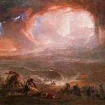
- Why It Matters: It has transformed understanding of the scale of organized violence in Bronze Age Europe.
The Tollense Valley has become one of the most consequential prehistoric discoveries in Europe because it preserves the remains of a large Bronze Age conflict. Human bones, weapons, and associated finds recovered from the riverine landscape indicate violence on a scale once thought unlikely for this period in northern Europe. Instead of scattered local skirmishes, the site points to organized combat involving substantial numbers of participants. As a result, it has forced historians to rethink assumptions about hierarchy, mobility, and military capacity in the late Bronze Age of central Europe. In the wider map of Archaeological Sites in Germany, Tollense has become the benchmark for discussing prehistoric warfare at scale.
What makes Tollense distinctive is the combination of human remains, weapon-related evidence, and environmental context. The river, causeway, and sediment conditions helped preserve traces that would often disappear elsewhere. Analyses of bones, trauma, isotopes, and artifacts have supported debate about where participants came from and how the conflict unfolded. Some questions remain open, but that uncertainty is part of the site’s value: it shows how archaeology builds interpretations from converging lines of evidence rather than from certainty alone. The site therefore functions as both a discovery and a methodological case study.
Tollense reveals that Bronze Age societies could mobilize fighters, coordinate movement, and produce violence at an unexpectedly large scale. It also illuminates the human cost of that organization, reminding us that political complexity often leaves a brutal signature in the archaeological record. Today the valley matters because it expands the possible scale of prehistoric history in the public mind. It proves that early Europe was not simple, static, or uniformly peaceful, and that correction is historically important.
Feddersen Wierde
- Location: Lower Saxony, near the North Sea coast
- Period / Civilization: Roman Imperial era to Migration-period context
- Type of Site: Rural settlement mound
- Why It Matters: It is one of the best-studied settlements for everyday life in northern Germania outside Roman urbanism.
Feddersen Wierde offers something many famous monuments cannot: a detailed picture of ordinary settlement life. This rural mound settlement, occupied for centuries in northern Germany, has been fundamental for reconstructing domestic architecture, storage, animal husbandry, and local social organization in communities beyond Roman urban control. It is historically important because it shifts the lens away from elites, armies, and ceremonial centers toward households and agricultural life. In the broader map of Archaeological Sites in Germany, that makes it essential rather than secondary.
Excavation at Feddersen Wierde revealed house plans, farm structures, fencing, activity zones, and material remains that help archaeologists understand how a community organized work and space over time. Because the settlement was studied extensively and with attention to layout, it became a benchmark for discussing rural northern German societies during the Roman Imperial and Migration periods. The site’s distinctive value lies less in one spectacular object than in its coherent settlement pattern, which allows researchers to reconstruct lived environments with unusual depth.
Feddersen Wierde reveals that the ancient past was built from routines: feeding animals, storing grain, repairing structures, managing kin ties, and adapting to coastal conditions. These are the foundations of social history, and without such sites, the past becomes distorted toward rulers and battles. Its present-day relevance is therefore intellectual as much as cultural. It teaches that ordinary life leaves a record worth protecting, and that seemingly modest sites can answer some of the biggest historical questions.
What These Sites Reveal About Ancient Life in Germany
Taken together, these places show that ancient life in Germany was organized through a constant balancing of subsistence, power, belief, and movement. Forts and city gates speak to administration, taxation, and military logistics. Hillforts and princely centers reveal ranked societies in which prestige, ceremony, and political display mattered. Enclosures such as Goseck suggest that timekeeping, seasonal ritual, and shared cosmology shaped communal life long before writing. Rural settlements like Feddersen Wierde bring the story down to households, animals, storage, and the ordinary maintenance without which no larger political structure could endure.
They also show that trade and exchange were not late additions but long-running forces. Imported goods, crafted metal, coinage, harbor activity, and route control appear across periods, from Iron Age elite centers to Roman towns and Viking emporia. The Archaeological Sites in Germany examined here collectively preserve the archaeological heritage of Germany as a record of contact: goods moved, people moved, ideas moved, and with them came new technologies, new rituals, and new forms of hierarchy. Burial customs, warfare injuries, monumental building, and workshop debris all point to societies that were dynamic, unequal, and often intensely connected to wider regions.
Perhaps most importantly, these sites reveal human scale. Behind every wall, ditch, gate, grave, and artifact were choices about food, labor, trust, danger, devotion, and memory. Archaeology makes those choices visible in fragments, but once assembled, the fragments tell a remarkably intimate story.
Preservation Challenges Facing Archaeological Sites in Germany
Germany’s archaeological record is well studied, but it is not immune to damage. Erosion, groundwater changes, agriculture, infrastructure expansion, unauthorized metal detecting, and the sheer pressure of modern development can all destroy context long before a site is fully understood. Open-air remains are especially vulnerable because weathering and visitor traffic can wear down surfaces faster than conservation budgets can respond. Large landscapes such as battlefields and earthworks face an additional problem: they are easy to fragment because their significance lies across wide terrain rather than in one fenced monument.
Preservation matters because archaeology is a nonrenewable archive, and the future of Archaeological Sites in Germany depends on keeping context intact rather than treating artifacts as isolated trophies. Once layers are disturbed without documentation, information about chronology, use, and relationship is lost permanently. Museums, regional heritage offices, research institutions, and site managers all play a role in slowing that loss, but stewardship also depends on public culture. The German Archaeological Institute and local state heritage authorities matter not simply because they supervise excavation; they help turn fragile evidence into shared knowledge that can survive beyond the excavation season.
Conservation also raises ethical questions. How much should be reconstructed? How should contested or incomplete interpretation be presented? When should a site be excavated, and when is it better left undisturbed for future methods? Responsible preservation means admitting that protection is not just about keeping ruins visible. It is about protecting context, uncertainty, and the possibility of better questions in the future.

The Archaeological Legacy of Germany
The long-term legacy of these sites is not a single national origin story. Instead, they show a region repeatedly shaped by convergence: local communities, Roman power, Iron Age elites, maritime traders, and early medieval states all left overlapping material claims on the same landscapes. That is why Archaeological Sites in Germany matter intellectually: they resist simple narratives and force a more layered account of how societies develop. Germany’s past was not linear, and its archaeological record preserves that complexity in unusually vivid form.
They also shape the country’s present image in deeper ways than tourism branding suggests. Roman remains in Trier, Celtic centers in Hesse, Bronze Age ceremonial sites in Saxony-Anhalt, and Viking-linked settlements in Schleswig-Holstein are not just regional curiosities. They are among the cultural landmarks of Germany because they anchor public memory in evidence rather than myth. In that broader civic sense, Archaeological Sites in Germany help modern audiences see the country not only through recent history, but through millennia of experimentation, exchange, settlement, and survival.
Conclusion
To read Germany archaeologically is to see a landscape of extraordinary continuity and transformation. Roman gates, frontier forts, princely hilltops, ritual circles, battlefields, trading towns, and rural settlements all speak in different registers, yet together they reveal a long human drama of adaptation, ambition, conflict, and belief. That is the lasting value of Archaeological Sites in Germany: they make the country’s deep past legible in material form, and they remind us that Europe’s center has always been a place of encounter rather than historical stillness.
Preserving these places is not only about protecting old stone or buried artifacts. It is about defending evidence, context, and the discipline of historical responsibility itself. When these sites are studied carefully and presented honestly, they do more than enrich scholarship; they deepen public understanding of how societies are built, how they change, and how fragile their traces can be. That is exactly why they deserve long attention now.
Q1: What is the most famous archaeological site in Germany?
Q2: Are Germany's key archaeological sites mostly Roman?
Q3: Why is the Tollense Valley important?
Q4: What do Archaeological Sites in Germany reveal most clearly?
Q5: Is the Nebra Sky Disc still debated?
Q6: Why does preservation matter so much?