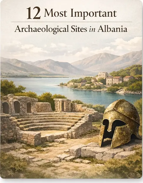
Albania is often discussed through its mountains, coast, and strategic Adriatic position, but its deepest story lies underfoot. Archaeological Sites in Albania form one of the clearest ways to understand how Illyrian communities, Greek colonists, Roman administrators, Byzantine clergy, and medieval powers all used the same landscapes in different ways. Across the south, central plains, and western littoral, excavated theaters, fortification lines, burial mounds, urban grids, and sanctuaries show how the territory linked the Balkans to the wider Mediterranean. For readers willing to look beyond postcard scenery, this is a country where settlement continuity, political reinvention, and cultural exchange can be traced in stone, pottery, road alignments, and tomb architecture.
That is why any serious survey of Archaeological Sites in Albania has to move beyond a simple list of monuments. Albania preserves port cities, hilltop strongholds, ceremonial cemeteries, and urban centers that reveal how power was organized, how trade moved, how religious life changed, and how local elites adapted to larger imperial systems. The most compelling part of the story is not only that sites survived, but that they preserve evidence from multiple eras in the same footprint. In this sense, the country’s archaeological map functions almost like a layered archive, where each excavation season helps clarify how communities met, fought, worshipped, and remembered their dead.
What makes this landscape especially compelling is the way local and regional histories intersect. Sites in southern Albania speak to Epirus and the Greek world, central sites illuminate Roman administration and long-distance movement, while burial landscapes in the southeast preserve evidence for older ritual and social traditions. Even the ancient ruins in Albania are rarely mute ruins; they remain active reference points for scholarship, museums, heritage policy, and public memory. Taken together, they show that Albania was never peripheral to history. It was a contact zone, a corridor, and at times a frontier whose material record still challenges simplified narratives of the ancient Balkans.
Why Archaeological Sites in Albania Matter
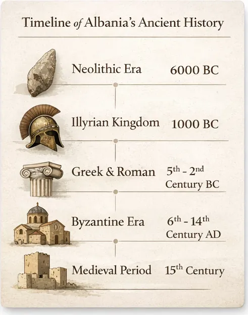
The territory of modern Albania sits at the meeting point of the Adriatic and Ionian worlds, the interior Balkans, and the routes that connected Italy with the eastern Mediterranean. That geography helped make it significant long before modern borders existed. Prehistoric communities left burial monuments and settlement traces; Iron Age groups associated with Illyrian identities established fortified centers; Greek-speaking colonies and neighboring Epirote communities developed ports, sanctuaries, and civic institutions; Rome later reorganized key settlements into administrative and commercial nodes; and Byzantine and medieval layers often overlaid older foundations rather than replacing them entirely. Few countries in southeastern Europe present such visible, compact evidence for continuity through so many political systems.
Archaeology matters here because written sources for early Balkan history are uneven, external, and often biased toward the concerns of Greek and Roman authors. Excavated architecture, coins, ceramics, inscriptions, fortifications, and funerary monuments therefore carry unusual weight. They help historians test literary claims, identify local adaptations, and understand how regional communities used imported forms for their own purposes. In Albania, archaeology is not merely supplementary evidence; it is often the best way to reconstruct the rhythms of settlement, exchange, and authority on the ground.
Archaeological Sites in Albania and the Deep Historical Record
The density of sites across Albania is meaningful because it reflects more than isolated episodes of urban development. Valleys, river corridors, and coastal plains encouraged repeated occupation, while hilltops provided defensible positions and visual control over trade routes. Ancient communities did not choose these settings randomly. Ports served maritime exchange, acropoleis protected elites and storage, and inland roads tied local production to broader regional markets. When a site such as Butrint or Apollonia grew, it did so within a wider landscape of farms, cemeteries, workshops, and satellite settlements that made urban life possible.
Seen together, these places reveal long duration rather than disconnected brilliance. A Hellenistic wall might stand near Roman baths; a late antique basilica may occupy a zone once shaped by pagan civic life; a medieval reuse of earlier masonry can show how later societies inherited and reinterpreted the ancient built environment. For readers, that larger pattern matters because it turns the site list below into more than an inventory. It becomes a civilizational map of repeated settlement, adaptation, and survival.
A Brief Historical Timeline of Albania
Albania’s archaeological sequence begins with prehistoric occupation, including Neolithic and later Bronze Age communities that left habitation traces and tumulus burials in several regions. By the early first millennium BCE, fortified hill settlements and regional identities associated with Illyrian groups had become more visible. In the south, Epirote communities and the Chaonians emerged as important actors, while coastal contact with the Greek world intensified through colonization and exchange. The result was not a single cultural line, but a landscape shaped by overlapping traditions, local authority, and maritime contact.
From the sixth century BCE onward, places such as Apollonia became major colonial and commercial points, while inland centers developed more formalized urban forms during the Hellenistic period. The rise of Macedonian and then Epirote power affected the region, and the campaigns of Pyrrhus left direct marks in the foundation of cities such as Antigonea. Roman intervention gradually transformed the political order, and once the area entered the Roman sphere, roads, civic monuments, amphitheaters, baths, and municipal institutions altered the scale and language of public space. Readers looking for broader Mediterranean context can find a helpful overview in History’s guide to the Roman Empire, which explains the imperial framework that shaped many Albanian sites.
Late antiquity brought new religious architecture, fortified reorganization, and changing urban priorities as Christianity spread and political power shifted. Byzantine rule, medieval polities, Venetian interests, and Ottoman expansion then layered new structures and habits onto older sites. That long arc matters because the visible record is not the product of one kingdom or one era. It is the accumulated material history of the ancient civilizations of Albania, local communities, and later empires that reused the same strategic spaces for very different purposes.
Butrint: A Landmark Among the Archaeological Sites in Albania
- Location: Near Saranda, in southern Albania, beside the Vivari Channel and within Butrint National Park.
- Period / Civilization: Prehistoric occupation, Greek and Hellenistic phases, Roman, Byzantine, Venetian, and medieval layers.
- Type of Site: Multi-period ancient city, sanctuary, port settlement, and fortified archaeological complex.
- Why It Matters: It preserves one of the most continuous and layered urban records in the Balkans and is Albania’s best-known UNESCO-listed ancient site.
Butrint, known in antiquity as Buthrotum, is the clearest example of how one Albanian site can preserve many historical worlds in the same landscape. Occupation in the area reaches back to prehistory, but the city became especially important as a Greek-associated center tied to Epirus and the wider Ionian sphere. Later, Roman rule transformed it into a colonia with new civic investment, while late antique and Byzantine communities added churches and defensive works. Because the site occupies a lagoon-edge setting with direct access to maritime routes, it was never only a ceremonial place. It was also a strategic settlement shaped by trade, ritual, agriculture, and political control. Few places in the country show so clearly how the same topography could sustain urban life across dramatic changes in language, religion, and imperial power.
Its distinctive value lies in the survival of multiple monumental and infrastructural elements within a coherent archaeological park. Visitors and researchers can trace the theater, city walls, a Roman forum area, baths, a baptistery famous for its mosaic flooring, and later ecclesiastical architecture. Excavations have also produced ceramics, inscriptions, coins, and evidence of changing building phases that help specialists date transformations in the city’s civic and religious center. The combination of standing ruins and excavated evidence makes Butrint unusually legible. Instead of one signature monument, it offers a sequence of urban forms that can be read against one another, revealing how prosperity, decline, revival, and reconfiguration played out over centuries.
As one of the most studied Archaeological Sites in Albania, Butrint reveals how ancient communities balanced sacred practice, maritime exchange, social hierarchy, and later Christian reorganization. Domestic remains, imported goods, and the city’s long occupation suggest not a frozen classical town but an adaptable place integrated into regional networks. It also demonstrates why archaeology matters beyond tourism: Butrint is central to debates about conservation, site management, and how to present layered heritage without flattening it into a single era. Its preservation has strong symbolic value for Albania, because the site shows that the country’s past is not a footnote to neighboring histories, but a major chapter of Mediterranean antiquity in its own right.
Apollonia
- Location: Near Fier, on a hill above the Vjosa plain and not far from the Adriatic coast.
- Period / Civilization: Greek colonial foundation in the sixth century BCE, later Hellenistic and Roman phases.
- Type of Site: Ancient city with civic, religious, residential, and educational remains.
- Why It Matters: It was one of the great urban centers of the region and preserves a major record of colonial, Hellenistic, and Roman civic life.
Apollonia was founded by colonists from Corinth and Corcyra and developed into one of the most influential cities on the eastern Adriatic. Its success depended on fertile hinterlands, access to maritime exchange, and its position within the communications network of the wider Greek world. Over time, it grew into a substantial city with political institutions, sanctuaries, and an urban identity that outlasted its colonial origins. Under Roman influence, Apollonia remained important enough to be woven into imperial systems of movement, education, and administration. The city is often remembered in connection with Octavian, the future Augustus, who is traditionally said to have studied there, a detail that reflects the place’s prestige in the late republican world.
The site is especially valued for the clarity of its monumental remains and the depth of excavation carried out there. Archaeologists have documented a bouleuterion, library-related remains, stoas, temples, sections of the city wall, and residential zones that together map the shape of civic life. Sculpture fragments, inscriptions, coins, pottery, and architectural pieces have helped scholars reconstruct both public ideology and everyday function. Apollonia is not unique because it was large, but because the preserved remains show how political authority, ritual space, and urban planning were integrated in a thriving Adriatic city. Its archaeological footprint is broad enough to illuminate institutional life rather than only isolated monumentality.
In human terms, Apollonia helps explain how urban communities negotiated identity in a region where local populations, colonists, merchants, and imperial officials all intersected. The site shows evidence for literacy, trade, education, religious performance, and social stratification, all anchored in a well-organized civic landscape. Because of that, Apollonia stands among the most instructive Archaeological Sites in Albania for understanding how cities mediated between local realities and the grand narratives of Greece and Rome. Its present relevance is equally strong: every new excavation or conservation effort refines how Albania presents classical urbanism within its own historical framework, rather than as an imported chapter detached from local development.
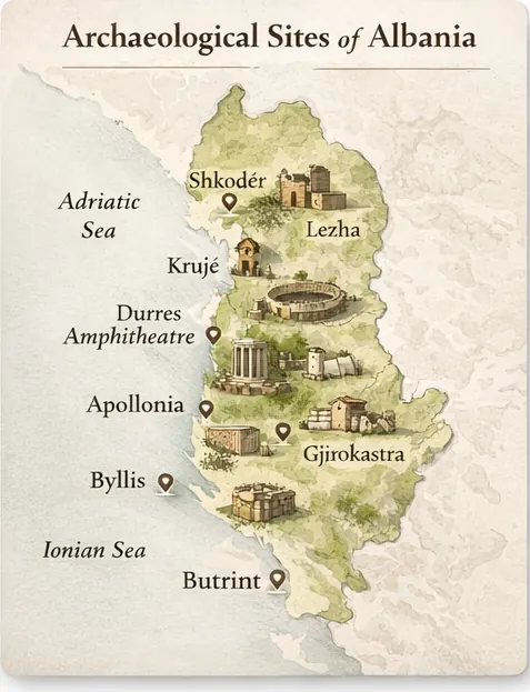
Byllis
- Location: In Mallakastra, above the Vjosa valley in southwestern Albania.
- Period / Civilization: Illyrian and Hellenistic city, with important Roman and late antique phases.
- Type of Site: Fortified hilltop city with public buildings, walls, and later Christian remains.
- Why It Matters: It shows how inland power, defense, and urban form developed away from the coast.
Byllis occupied a commanding height overlooking routes through the Vjosa basin, and that alone explains much of its historical role. It was an inland urban center tied to Illyrian and later Hellenistic political formations, benefiting from its ability to monitor movement across a strategically important landscape. Unlike coastal cities whose prominence depended strongly on maritime exchange, Byllis illustrates the logic of a fortified interior center: surveillance, defense, administration, and regional control. Over time, the site remained active enough to acquire later Roman and Christian layers, showing that its setting continued to matter even as political systems changed.
The city’s most distinctive features include substantial fortification circuits, a theater, street planning, and later ecclesiastical remains that point to continued importance in late antiquity. Excavated architectural fragments, pottery, and inscriptions help scholars trace the adaptation of a strongly defended settlement into a more complex urban community. Byllis is especially useful for studying how local and external influences interacted, because its layout combines regional defensive priorities with architectural forms associated with the broader Hellenistic world. The site does not simply imitate Mediterranean models; it adapts them to a hilltop context where visibility and enclosure remained central.
As one of the more revealing Archaeological Sites in Albania, Byllis helps historians think about how inland communities organized authority, protected resources, and projected status. Its ruins also clarify how religious life and urban continuity persisted even after earlier political structures changed. For the modern reader, the site matters because it widens the picture of Albanian antiquity beyond famous ports and monumental showpieces. Preserving Byllis means preserving evidence that power in the ancient Balkans was not only coastal, not only colonial, and not only Roman. It was also local, elevated, and deeply shaped by terrain.
Antigonea
- Location: Near Gjirokaster, in the Drino valley of southern Albania.
- Period / Civilization: Hellenistic foundation traditionally associated with Pyrrhus of Epirus, later Roman destruction and limited reuse.
- Type of Site: Planned ancient city with fortifications and urban street grid.
- Why It Matters: It is a rare, legible Hellenistic urban foundation tied to one of the best-known rulers of the region.
Antigonea is closely associated with Pyrrhus, the Epirote king whose military campaigns made him famous far beyond the Balkans. The city is generally understood to have been founded in the early Hellenistic period, likely as a royal project named for his wife Antigone. That origin gives the site unusual interpretive value, because it links urban foundation directly to dynastic ambition and territorial strategy. Situated above the Drino valley, the city occupied a position that combined visibility, control, and symbolic authority. Even though its active life as a major center was comparatively brief, the site remains one of the most eloquent statements of planned Hellenistic power in Albania.
Archaeologically, Antigonea is prized for its urban grid, visible road lines, fortification remains, and the evidence it preserves for organized civic design. Excavations have identified domestic structures, public space, ceramics, coins, and construction techniques that help reconstruct its date and function. Because the city appears to have suffered major destruction in the Roman period, it also offers a relatively concentrated snapshot of a Hellenistic foundation rather than a heavily overbuilt, many-layered urban palimpsest. That makes it especially useful to archaeologists studying settlement planning, state-sponsored urbanism, and the political messaging embedded in city layout.
The human story of Antigonea is one of ambition, instability, and memory. It shows how rulers used city-building to secure territory and project legitimacy, but also how vulnerable such projects could be in a contested political landscape. For readers comparing major historic sites in Albania, Antigonea stands out because its importance lies less in long continuity and more in the sharp archaeological visibility of one historical moment. Today, the site matters as a reminder that even short-lived foundations can illuminate governance, household life, and regional conflict with exceptional clarity.
Phoenice
- Location: Above modern Finiq in southern Albania.
- Period / Civilization: Epirote and Chaonian center with Hellenistic and Roman phases.
- Type of Site: Fortified acropolis and urban settlement with civic and religious remains.
- Why It Matters: It was a major political center of the Chaonians and an important node in ancient Epirus.
Phoenice, often identified as a leading center of the Chaonians, occupies one of the most historically important heights in southern Albania. Its significance comes not only from architecture but from political identity. In antiquity, the city served as a major Epirote center, linking regional power with broader Greek-speaking networks. Its elevated position gave it defensive strength and a commanding view over surrounding land, making it ideal for administration and symbolic control. In literary and archaeological terms alike, Phoenice helps anchor the history of Epirus within the territory of modern Albania, offering a counterweight to coast-focused narratives.
Excavation and survey have highlighted substantial walls, terraces, domestic traces, public structures, and artifacts that speak to long occupation and organized civic life. The scale of its fortifications is especially striking, underscoring the importance of defense and status. Coins, ceramics, and structural remains indicate sustained economic and social activity, while the site’s topography helps explain how the acropolis and broader urban area functioned together. Phoenice is distinctive because its importance is simultaneously political, regional, and topographical: the hill itself is part of the argument for why the city mattered.
Among the leading Archaeological Sites in Albania, Phoenice offers insight into how upland centers expressed authority before and during wider imperial transformations. It reveals patterns of elite occupation, regional administration, and community organization that do not depend on being a Roman colonia or a Greek colonial port. That makes it especially valuable for understanding local political traditions in the south. Its present-day relevance is equally strong, because continued study of Phoenice helps correct older historical narratives that treated Epirote and Chaonian landscapes as marginal rather than central to Balkan antiquity.
Amantia
- Location: In the Vlora region, inland from the coast in southern Albania.
- Period / Civilization: Illyrian and Hellenistic, with later Roman presence.
- Type of Site: Fortified ancient city with public architecture and defensive works.
- Why It Matters: It preserves a strong example of regional urbanism shaped by local identities and wider Mediterranean forms.
Amantia occupies a high position that immediately signals its original priorities: security, oversight, and territorial control. The city is associated with southern Illyrian and Hellenistic developments, and it stands as a reminder that urbanization in the region was not simply imported from the coast. Local communities adopted and adapted urban forms in ways that served existing political and geographic realities. Amantia therefore belongs to a crucial category of Albanian sites: places that demonstrate how regional centers could be both locally rooted and visibly connected to broader Hellenistic patterns of architecture and public life.
The site is known for its fortification walls, stadium area, temple-related remains, and the broader organization of its hilltop setting. Finds from excavations, including pottery, coins, and architectural fragments, have helped establish phases of occupation and changing use. What makes Amantia especially instructive is the way its built environment combines the language of civic architecture with the logic of a defensible upland stronghold. It was not only a place to live; it was a place designed to secure, display, and organize power. That combination makes it one of the clearest examples of regionally distinctive urban development in southern Albania.
As a quietly important Albanian site, Amantia reveals how communities in the interior balanced ceremony, athletic culture, storage, defense, and everyday domestic life. The evidence suggests a socially layered settlement whose inhabitants participated in wider economic and cultural networks without surrendering local priorities. Today, the site’s value lies in how it broadens the story of Albania beyond iconic names. It reminds readers that the archaeological map is richest when lesser-known centers are preserved with the same seriousness as headline monuments.
Durres Amphitheatre
- Location: In the center of modern Durres, ancient Dyrrhachium, on Albania’s Adriatic coast.
- Period / Civilization: Roman, mainly second century CE, with later Christian reuse.
- Type of Site: Amphitheatre and associated urban archaeological remains.
- Why It Matters: It is one of the largest Roman amphitheatres in the Balkans and a powerful example of ancient spectacle embedded in a living city.
The Durres Amphitheatre belongs to the Roman phase of ancient Dyrrhachium, one of the most important ports on the Adriatic. Its construction speaks directly to the civic culture of the empire, where monumental entertainment venues expressed wealth, public status, and the political language of Roman urban life. Built within a dense city rather than in isolation, the amphitheatre reminds us that spectacle in antiquity was not separate from everyday movement, commerce, and authority. The fact that it survives inside a modern urban center also highlights a different historical continuity: the same strategic coastal site has remained central for centuries.
What makes the monument distinctive is not just its size, but the way later history settled into it. Archaeologists have documented structural features of the arena and seating, as well as later Christian modifications, including a chapel with wall paintings. This layered reuse transforms the amphitheatre from a single-purpose Roman monument into a case study in changing urban priorities. Excavation has also been unusually challenging because of the modern city surrounding it, making every preserved section especially valuable for reconstructing the full extent and sequence of the monument.
As one of the most accessible Archaeological Sites in Albania, the Durres Amphitheatre reveals how imperial entertainment, religious change, and modern urban pressure can all occupy the same physical space. It shows Roman ideas of crowd control, civic display, and public ritual, but also the later repurposing of monumental architecture by Christian communities. For present-day Albania, the site is a vivid lesson in why protection is difficult yet urgent: archaeology here is not remote. It is woven directly into the fabric of a busy port city.
Lissus
- Location: At Lezha in northwestern Albania, near the Drin river system and the Adriatic approaches.
- Period / Civilization: Illyrian, Hellenistic, Roman, and later Byzantine phases.
- Type of Site: Fortified ancient city and strategic settlement with acropolis remains.
- Why It Matters: It controlled a key northern corridor linking inland routes with the coast.
Lissus, identified with ancient Lezha, mattered because it occupied a strategic threshold between coastal communications and the interior of the western Balkans. This made it attractive to successive powers, from local Illyrian authorities to later Roman and Byzantine administrations. Its historical role was therefore both military and commercial. Whoever held Lissus could monitor movement, protect routes, and anchor influence in a region where river and road networks carried both goods and armies. The site stands as an important northern counterpoint to the better-known southern centers of Albania.
Archaeological remains at and around the acropolis point to strong fortification, long occupation, and repeated adaptation. The surviving walls and structural traces are especially valuable because they show how different periods reused defensible terrain rather than abandoning it. Material finds from the wider area help reconstruct phases of urban activity, exchange, and changing political control. Lissus is distinctive less for a single famous monument than for its strategic logic: the place itself explains the history. It is a city whose location continuously generated relevance.
For scholars, Lissus ranks among the important Archaeological Sites in Albania because it reveals how northern Albania participated in the same broader patterns of defense, trade, and political transition seen elsewhere in the country, but under different geographic constraints. It also helps connect archaeology to later historical memory, since Lezha remained symbolically significant in Albanian history. Today, the site deserves attention not only as an ancient ruin, but as a reminder that control of landscape was one of the deepest constants in Balkan political life.
Selca e Poshtme Royal Tombs
- Location: Near Pogradec in southeastern Albania, in a hilly landscape above old inland routes.
- Period / Civilization: Mainly fourth to third centuries BCE, associated with Illyrian elites.
- Type of Site: Rock-cut monumental tomb complex.
- Why It Matters: It offers rare, high-status funerary evidence for elite culture and political expression in pre-Roman Albania.
The royal tombs of Selca e Poshtme belong to one of the most important elite burial landscapes in Albania. Cut into rock and monumental in conception, they are associated with high-status Illyrian rulers or aristocratic lineages of the region. Their importance lies in the fact that funerary architecture can preserve forms of power that settlement ruins sometimes obscure. Here, burial itself became a public statement, expressing status, continuity, and political legitimacy through highly visible and carefully crafted stone chambers. In that sense, the site is a key source for understanding local rulership before Roman political frameworks took hold.
The tombs are distinguished by their carved facades, chamber organization, and the broader landscape setting that turns burial into a monumental act. Excavation and study have produced grave goods and architectural details that help date the complex and interpret the social rank of those interred there. Scholars pay close attention to such sites because tomb design can reveal cultural borrowing, local identity, and the symbolic language of power. Selca e Poshtme is particularly valuable precisely because elite burials of this scale are comparatively rare and therefore disproportionately informative.
As one of the more specialized Archaeological Sites in Albania, Selca e Poshtme reveals how burial customs communicated hierarchy, ancestry, and social ambition. It helps historians ask who controlled wealth, how prestige was displayed, and what the dead were expected to signify for the living community. Today, the tombs matter because they remind readers that archaeology is not only about cities and fortresses. Cemeteries can be equally central to understanding how societies organized themselves, remembered authority, and imagined continuity across generations.
Kamenica Tumulus
- Location: Near Korca in southeastern Albania.
- Period / Civilization: Bronze Age to early Iron Age funerary horizon, with long use across prehistoric phases.
- Type of Site: Tumulus cemetery and prehistoric burial monument.
- Why It Matters: It is one of the richest prehistoric burial sites in the country and a key source for understanding early communities.
The Kamenica Tumulus takes the reader far earlier than the classical cities that dominate most discussions of Albania’s past. This burial mound, used over a long span of prehistory, preserves evidence for communities whose social organization predated written sources. That alone makes it indispensable. Prehistoric archaeology must often work without named rulers, battles, or textual narratives, so burial contexts become essential for reconstructing social patterns, ritual, craft, and chronology. Kamenica is important because it opens a window onto the deep human past of southeastern Albania before urban institutions and empires shaped the landscape.
Excavation at the tumulus has produced a large number of burials and associated finds, including ceramics, ornaments, weapons, and other grave goods that allow archaeologists to distinguish phases of use and changing funerary practice. These materials help build relative chronologies and reveal distinctions in status, gender roles, and ritual habit. The site is especially significant because the density of burials creates a broad sample rather than an isolated deposit. This makes Kamenica a cornerstone for interpreting prehistoric lifeways, technological change, and the emergence of social differentiation.
Kamenica matters today because it reveals that the story of Albania does not begin with colonies, kings, or Roman roads. Long before that, communities were already burying their dead with meaningful patterns, producing crafted objects, and maintaining ritual landscapes across generations. The site therefore deepens public understanding of ancestry and belonging, while also reminding heritage authorities that prehistoric places can be more fragile and less visible than monumental cities. What looks like a mound can, in fact, preserve centuries of human memory.
Orikum
- Location: Near the Bay of Vlora in southwestern Albania.
- Period / Civilization: Greek and Hellenistic origins with Roman and later phases.
- Type of Site: Ancient coastal city and port settlement.
- Why It Matters: It illuminates the maritime dimension of southern Albania and the strategic logic of coastal settlement.
Orikum occupied an enviable position near one of the key maritime zones of the Albanian coast. Its ancient role was inseparable from seafaring, coastal exchange, and the strategic relationship between harbors, hinterland routes, and military movement. Though less famous than Butrint or Apollonia, the site is important precisely because it helps fill out the network of smaller but consequential ports that connected the region to wider Adriatic and Ionian systems. In antiquity, control of such places could matter enormously even when they lacked the monumental scale of larger cities.
Archaeological work has identified urban remains, defensive elements, and material finds that confirm long use and changing coastal functions. The significance of Orikum lies in how it captures the practical side of maritime history: anchorage, provisioning, movement, and the relationship between local settlement and regional navigation. Its remains are not only evidence of a city, but of a corridor where trade, communication, and strategic planning intersected. Sites like this often seem modest until one asks how larger polities actually moved people and resources through the landscape.
Orikum reveals that ancient life in Albania was shaped as much by sea lanes as by mountain passes. The city helps archaeologists reconstruct merchant traffic, local production, and the defensive priorities of a coast exposed to opportunity and threat in equal measure. Today, its value lies in restoring proportion to the national story: not every crucial site was a grand capital. Some were working ports whose importance becomes clear only when the wider network is understood.
Hadrianopolis
- Location: Near Sofratike in the Gjirokaster region of southern Albania.
- Period / Civilization: Roman and late antique.
- Type of Site: Urban archaeological site with theater and associated civic remains.
- Why It Matters: It shows Roman-era urban development in the Drino valley beyond the more famous Hellenistic foundations.
Hadrianopolis belongs to the Roman phase of southern Albania’s urban history and helps show how imperial administration extended into inland valleys that already had long settlement traditions. The city developed in a landscape that had earlier importance, but the Roman imprint gave it a new civic language through planned public architecture and urban amenities. This matters because it demonstrates how Rome did not simply occupy old centers; it also reorganized space through new institutional and monumental priorities. In the Drino valley, Hadrianopolis helps bridge the story between earlier Hellenistic sites and later late antique transformations.
The site’s best-known remains include a theater and traces of associated urban structures, while excavation and survey have produced architectural fragments and artifacts that clarify the scale and chronology of occupation. The monumentality of the theater is especially revealing, since such buildings were not merely entertainment venues: they announced civic ambition, social ordering, and participation in the public culture of the empire. Hadrianopolis is distinctive because it documents Roman urban aspiration in a valley already rich with earlier political history. It is a reminder that imperial systems often worked by layering new institutions onto landscapes already dense with memory.
For readers, Hadrianopolis matters because it reveals how deeply Rome reshaped everyday rhythms, from public gatherings to movement through urban space. It also shows why archaeology must track continuity and change together. A Roman city in southern Albania is never only Roman; it is also part of a longer regional story about settlement, adaptation, and shifting centers of authority. Protecting the site ensures that this middle layer of the country’s past remains visible rather than disappearing between more famous prehistoric and Hellenistic narratives.
What These Sites Reveal About Ancient Life in Albania
Viewed together, these sites show that ancient life in Albania was structured by practical needs as much as by political ambition. Households stored grain, crafted ceramics, buried relatives with ritual care, and relied on roads, rivers, harbors, and defended heights to survive in a competitive landscape. Trade emerges repeatedly, whether through imported goods at port cities, coin circulation in inland settlements, or the positioning of towns near corridors of movement. Religion also appears in multiple forms, from sanctuaries and civic ritual to Christian churches inserted into older urban settings. In this broader sense, Archaeological Sites in Albania are valuable because they restore the lived texture of the past rather than reducing history to rulers and dates. They also help clarify the archaeological heritage of Albania, showing how local craftsmanship, foodways, burial customs, hierarchy, and cultural borrowing were woven into daily experience.
The social picture that emerges is layered and dynamic. Elite tombs point to hierarchy and political display; amphitheatres and theaters show collective performance and the management of crowds; fortification walls speak to insecurity and organized labor; and city plans reveal how governance was made visible in streets, storage, and public buildings. These places also prove that cultural exchange was not abstract. Imported styles, local building choices, reused sacred space, and changing funerary habits all show people making decisions within larger systems of pressure and opportunity. The ancient inhabitants of Albania were not passive recipients of outside influence. They actively shaped how broader Mediterranean forms were adopted, resisted, or transformed.
Preservation Challenges Facing Albania’s Archaeological Heritage
Protecting major sites in Albania is an ongoing challenge because archaeology here must coexist with weathering, vegetation, earthquakes, development pressure, tourism, and uneven funding. Coastal humidity and shifting water levels can damage exposed masonry; inland sites suffer from erosion, plant growth, and gradual structural instability; urban sites such as the amphitheatre at Durres face the constant pressure of surrounding modern life. Looting and informal construction remain concerns, while conservation ethics can be difficult when a site contains many periods and no single restoration philosophy fits all. That is why Archaeological Sites in Albania require not only excavation, but patient stewardship, legal protection, trained conservators, local museum support, and thoughtful public interpretation. A useful wider perspective comes from Smithsonian Magazine’s report on digital preservation of at-risk heritage sites around the world, which highlights how documentation itself can become a vital safeguard when monuments are vulnerable.
Preservation matters because archaeological sites are not renewable resources. Once an unrecorded layer is disturbed, a wall collapses, or a burial context is looted, information is lost permanently. For Albania, the stakes are especially high because the country’s archaeological record is one of its strongest sources for reconstructing early history beyond the limits of textual evidence. Responsible stewardship therefore protects cultural memory, scholarly knowledge, and public trust at the same time. The best conservation work does not freeze sites into museum props. It stabilizes them, studies them, and presents them honestly as complex, evolving places.
The Archaeological Legacy of Albania
The long-term legacy of Albania’s excavated landscape is that it makes the country’s development visible across immense stretches of time. Ports, fortresses, burial grounds, and inland cities reveal that the territory was repeatedly drawn into larger political systems without losing its local specificity. This is where Archaeological Sites in Albania become intellectually powerful: they show continuity without simplicity. The same valleys and coasts could serve Illyrian elites, Greek-speaking civic communities, Roman magistrates, Christian clergy, and medieval authorities, yet the material record keeps track of each transformation in different ways.
That legacy also shapes modern identity. Archaeology does not provide a single origin story, nor should it. What it offers instead is a disciplined way of recognizing complexity: the coexistence of local tradition, regional exchange, imperial power, and survival through adaptation. Read in that spirit, Archaeological Sites in Albania are not static relics. They are evidence that the country has long been a place of encounter, negotiation, and reinvention. Preserving and studying them is therefore not only about the past; it is also about how Albania understands itself as a historically layered European and Mediterranean society, one whose oldest traces remain among its most meaningful cultural landmarks of Albania.
Conclusion
Albania’s archaeological record is remarkable not merely because it is old, but because it is layered, varied, and historically articulate. From Butrint’s multi-period cityscape to the elite tombs of Selca e Poshtme and the prehistoric depth of Kamenica, the country preserves evidence for urban planning, ritual practice, imperial reorganization, and local resilience across centuries. Read together, the sites discussed above show that Archaeological Sites in Albania are essential for anyone trying to understand the Balkans beyond modern borders or simplified national stories. They reveal a landscape where communities repeatedly adapted to new pressures while leaving durable marks in stone, soil, and memory.
That is why the real value of these places lies in study and stewardship as much as in admiration. Albania’s ruins are not just remnants to be photographed; they are archives that help explain how ancient people lived, traded, governed, believed, buried their dead, and rebuilt after change. The more carefully they are preserved, the more clearly the country’s long history can be read by scholars, citizens, and future generations. In an age of rapid development and environmental stress, protecting this material past is one of the most responsible ways to protect historical understanding itself.
Q1: What is the most famous archaeological site in Albania?
Q2: Which Albanian site best represents Roman urban life?
Q3: Does Albania have prehistoric sites as well as classical ones?
Q4: Why do scholars study Archaeological Sites in Albania so closely?
Q5: What kinds of discoveries are common at these sites?
Q6: What is the biggest preservation issue today?